Bretten geodata
Bretten (Baden-Württemberg) is a populated place; located in Germany in Europe/Berlin (GMT+2) time zone. With population of 28,144 people, there are 502 cities with bigger population in this country. Compared to other cities in Germany, 82.6% of cities are located further ↑North; 68.9% of cities are located further →East and 55.8% of cities have higher elevation than Bretten. Note1
Administrative division(s):
- Level 1: Baden-Württemberg
- Level 2: Karlsruhe Region
- Level 3: Landkreis Karlsruhe
- Level 4: Bretten


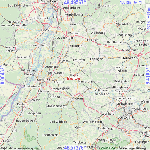
Bretten GPS coordinates[2]
49° 2' 12.66" North, 8° 42' 26.82" East
| Map corner | latitude | longitude |
|---|---|---|
| Upper-left | 49.49567°, | 8.00432° |
| Center: | 49.03685°, | 8.70745° |
| Lower-right: | 48.57376°, | 9.41057° |
| Map W x H: | 102.5×102.5 km | = 63.7×63.7mi |
| max Lat: | 55.01917° ⇑82.6% North |
| Bretten: | 49.03685° |
| min Lat: | ⇓17.4% South 47.40724° |
| min Long | Bretten | max Long |
| 5.92978° | 8.70745° | 14.98853° |
| W 31.1%⇐ | ⇒68.9% E |
Elevation
Elevation of Bretten is 183 m = 600 ft, and this is 66.1 m = 217 ft below average elevation for this country.
| Max E: |
1256 m = 4121 ft | 55.8% |
| Avg. | 249.1 m = 817 ft | |
| Bretten | 183 m = 600 ft | |
Min E: |
-5 m = -16 ft | 44.2% |
See also: Germany elevation on elevation.city.
Geographical zone
Bretten is located in North temperate zone (between Tropic of Cancer and the Arctic Circle). Distance of this North polar circle is 1948.8 km =1210.9 mi to North.| Distance of | km | miles | from Bretten |
|---|---|---|---|
| North Pole | 4554.7 | 2830.2 | to North |
| Arctic Circle | 1948.8 | 1210.9 | to North |
| Tropic Cancer | 2846.5 | 1768.7 | to South |
| Equator | 5452.4 | 3388 | to South |


Nearby cities:
15 places around Bretten: (largest is in red/bold)
• Dürrenbüchig
4.7 km =2.9 mi,  247°
247°
• Eisingen
10.1 km =6.3 mi,  197°
197°
• Gondelsheim
4.4 km =2.7 mi,  304°
304°
• Jöhlingen
9.8 km =6.1 mi,  266°
266°
• Kieselbronn
11.9 km =7.4 mi,  164°
164°
• Knittlingen
3.8 km =2.4 mi,  110°
110°
• Königsbach-Stein
10.8 km =6.7 mi,  223°
223°
• Kürnbach
11 km =6.8 mi,  65°
65°
• Maulbronn
8.1 km =5 mi,  120°
120°
• Oberderdingen
7.7 km =4.8 mi, 65°
• Sternenfels
10.6 km =6.6 mi,  81°
81°
• Wössingen
7.8 km =4.8 mi, 249°
• Zaisenhausen
10.9 km =6.8 mi,  44°
44°
• Ölbronn-Dürrn
8.4 km =5.2 mi, 158°
• Ötisheim
10.3 km =6.4 mi,  139°
139°
Sources, notices
• [Note1] Compared only with cities in Germany existing in our database
• [Src1] Map data: © OpenStreetMap contributors (CC-BY-SA)
• [Src2] Other city data from geonames.org with taken over terms of usage.
• [Src3] Geographical zone / Annual Mean Temperature by Robert A. Rohde @ Wikipedia
