Gondelsheim geodata
Gondelsheim (Baden-Württemberg) is a seat of a fourth-order administrative division; located in Germany in Europe/Berlin (GMT+2) time zone. With population of 3,183 people, there are 3843 cities with bigger population in this country. Compared to other cities in Germany, 82.3% of cities are located further ↑North; 69.5% of cities are located further →East and 59.4% of cities have higher elevation than Gondelsheim. Note1
Administrative division(s):
- Level 1: Baden-Württemberg
- Level 2: Karlsruhe Region
- Level 3: Landkreis Karlsruhe
- Level 4: Gondelsheim


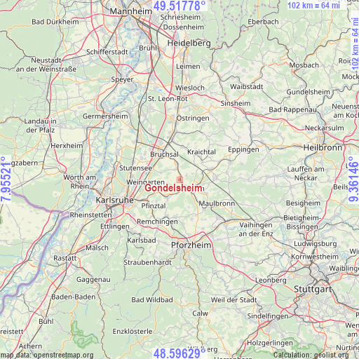
Gondelsheim GPS coordinates[2]
49° 3' 33.012" North, 8° 39' 29.988" East
| Map corner | latitude | longitude |
|---|---|---|
| Upper-left | 49.51778°, | 7.95521° |
| Center: | 49.05917°, | 8.65833° |
| Lower-right: | 48.59629°, | 9.36146° |
| Map W x H: | 102.5×102.5 km | = 63.7×63.7mi |
| max Lat: | 55.01917° ⇑82.3% North |
| Gondelsheim: | 49.05917° |
| min Lat: | ⇓17.7% South 47.40724° |
| min Long | Gondelsheim | max Long |
| 5.92978° | 8.65833° | 14.98853° |
| W 30.5%⇐ | ⇒69.5% E |
Elevation
Elevation of Gondelsheim is 157 m = 515 ft, and this is 92.1 m = 302 ft below average elevation for this country.
| Max E: |
1256 m = 4121 ft | 59.4% |
| Avg. | 249.1 m = 817 ft | |
| Gondelsheim | 157 m = 515 ft | |
Min E: |
-5 m = -16 ft | 40.6% |
See also: Germany elevation on elevation.city.
Geographical zone
Gondelsheim is located in North temperate zone (between Tropic of Cancer and the Arctic Circle). Distance of this North polar circle is 1946.3 km =1209.4 mi to North.| Distance of | km | miles | from Gondelsheim |
|---|---|---|---|
| North Pole | 4552.2 | 2828.6 | to North |
| Arctic Circle | 1946.3 | 1209.4 | to North |
| Tropic Cancer | 2848.9 | 1770.2 | to South |
| Equator | 5454.9 | 3389.5 | to South |


Nearby cities:
15 places around Gondelsheim: (largest is in red/bold)
• Bretten
4.4 km =2.7 mi,  124°
124°
• Bruchsal
8.5 km =5.3 mi,  328°
328°
• Dürrenbüchig
4.3 km =2.7 mi,  190°
190°
• Eisingen
12.2 km =7.6 mi,  177°
177°
• Forst
12.4 km =7.7 mi, 332°
• Jöhlingen
6.9 km =4.3 mi,  244°
244°
• Knittlingen
8.1 km =5 mi, 118°
• Kraichtal
11.1 km =6.9 mi,  29°
29°
• Königsbach-Stein
11.1 km =6.9 mi,  200°
200°
• Oberderdingen
10.6 km =6.6 mi,  86°
86°
• Ubstadt-Weiher
11.7 km =7.3 mi,  350°
350°
• Weingarten
9.6 km =6 mi,  266°
266°
• Wössingen
6.4 km =4 mi,  215°
215°
• Zaisenhausen
12.4 km =7.7 mi,  64°
64°
• Ölbronn-Dürrn
12.3 km =7.6 mi,  146°
146°
Sources, notices
• [Note1] Compared only with cities in Germany existing in our database
• [Src1] Map data: © OpenStreetMap contributors (CC-BY-SA)
• [Src2] Other city data from geonames.org with taken over terms of usage.
• [Src3] Geographical zone / Annual Mean Temperature by Robert A. Rohde @ Wikipedia
