Ramsen geodata
Ramsen (Rheinland-Pfalz) is a seat of a fourth-order administrative division; located in Germany in Europe/Berlin (GMT+2) time zone. With population of 1,863 people, there are 5257 cities with bigger population in this country. Compared to other cities in Germany, 75% of cities are located further ↑North; 76.9% of cities are located further →East and 51.3% of cities have higher elevation than Ramsen. Note1


Ramsen GPS coordinates[2]
49° 32' 12.984" North, 8° 0' 47.988" East
| Map corner | latitude | longitude |
|---|---|---|
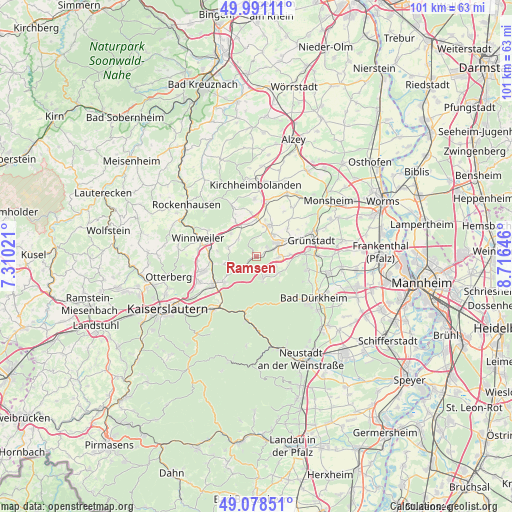
| Upper-left | 49.99111°, | 7.31021° |
| Center: | 49.53694°, | 8.01333° |
| Lower-right: | 49.07851°, | 8.71646° |
| Map W x H: | 101.5×101.5 km | = 63.1×63.1mi |
| max Lat: | 55.01917° ⇑75% North |
| Ramsen: | 49.53694° |
| min Lat: | ⇓25% South 47.40724° |
| min Long | Ramsen | max Long |
| 5.92978° | 8.01333° | 14.98853° |
| W 23.1%⇐ | ⇒76.9% E |
Elevation
Elevation of Ramsen is 216 m = 709 ft, and this is 33.1 m = 109 ft below average elevation for this country.
| Max E: |
1256 m = 4121 ft | 51.3% |
| Avg. | 249.1 m = 817 ft | |
| Ramsen | 216 m = 709 ft | |
Min E: |
-5 m = -16 ft | 48.7% |
See also: Germany elevation on elevation.city.
Geographical zone
Ramsen is located in North temperate zone (between Tropic of Cancer and the Arctic Circle). Distance of this North polar circle is 1893.2 km =1176.4 mi to North.| Distance of | km | miles | from Ramsen |
|---|---|---|---|
| North Pole | 4499.1 | 2795.6 | to North |
| Arctic Circle | 1893.2 | 1176.4 | to North |
| Tropic Cancer | 2902.1 | 1803.3 | to South |
| Equator | 5508 | 3422.5 | to South |


Nearby cities:
15 places around Ramsen: (largest is in red/bold)
• Altleiningen
5.4 km =3.4 mi,  127°
127°
• Breunigweiler
4.7 km =2.9 mi,  314°
314°
• Börrstadt
6.8 km =4.2 mi, 311°
• Carlsberg
4.2 km =2.6 mi,  150°
150°
• Dreisen
7.4 km =4.6 mi,  358°
358°
• Ebertsheim
7.7 km =4.8 mi,  63°
63°
• Eisenberg
4.9 km =3 mi, 60°
• Göllheim
7 km =4.3 mi,  22°
22°
• Hettenleidelheim
4.4 km =2.7 mi,  92°
92°
• Kerzenheim
5.5 km =3.4 mi,  37°
37°
• Neuhemsbach
7.3 km =4.5 mi,  252°
252°
• Sippersfeld
6 km =3.7 mi,  284°
284°
• Standenbühl
7.3 km =4.5 mi,  342°
342°
• Tiefenthal
6.5 km =4 mi, 88°
• Wattenheim
3.9 km =2.4 mi,  115°
115°
Sources, notices
• [Note1] Compared only with cities in Germany existing in our database
• [Src1] Map data: © OpenStreetMap contributors (CC-BY-SA)
• [Src2] Other city data from geonames.org with taken over terms of usage.
• [Src3] Geographical zone / Annual Mean Temperature by Robert A. Rohde @ Wikipedia
