Böllen geodata
Böllen (Baden-Württemberg) is a seat of a fourth-order administrative division; located in Germany in Europe/Berlin (GMT+2) time zone. With population of 93 people, there are 10861 cities with bigger population in this country. Compared to other cities in Germany, 97.8% of cities are located further ↑North; 80.1% of cities are located further →East and 98.2% of cities have lower elevation than Böllen. Note1
Administrative division(s):
- Level 1: Baden-Württemberg
- Level 2: Freiburg Region
- Level 3: Landkreis Lörrach
- Level 4: Böllen


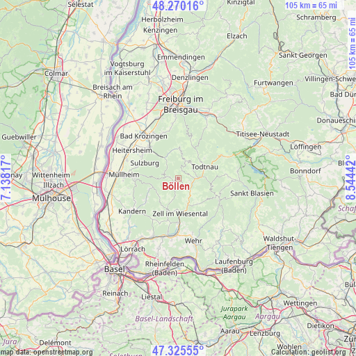
Böllen GPS coordinates[2]
47° 48' 0" North, 7° 50' 28.68" East
| Map corner | latitude | longitude |
|---|---|---|
| Upper-left | 48.27016°, | 7.13817° |
| Center: | 47.8°, | 7.8413° |
| Lower-right: | 47.32555°, | 8.54442° |
| Map W x H: | 105×105 km | = 65.2×65.2mi |
| max Lat: | 55.01917° ⇑97.8% North |
| Böllen: | 47.8° |
| min Lat: | ⇓2.2% South 47.40724° |
| min Long | Böllen | max Long |
| 5.92978° | 7.8413° | 14.98853° |
| W 19.9%⇐ | ⇒80.1% E |
Elevation
Elevation of Böllen is 720 m = 2362 ft, and this is 470.9 m = 1545 ft above average elevation for this country.
| Max E: |
1256 m = 4121 ft | 1.8% |
| Böllen | 720 m 2362 ft | |
| Avg. | 249.1 m = 817 ft | |
Min E: |
-5 m = -16 ft | 98.2% |
See also: Germany elevation on elevation.city.
Geographical zone
Böllen is located in North temperate zone (between Tropic of Cancer and the Arctic Circle). Distance of this North polar circle is 2086.3 km =1296.4 mi to North.| Distance of | km | miles | from Böllen |
|---|---|---|---|
| North Pole | 4692.2 | 2915.6 | to North |
| Arctic Circle | 2086.3 | 1296.4 | to North |
| Tropic Cancer | 2708.9 | 1683.2 | to South |
| Equator | 5314.9 | 3302.5 | to South |


Nearby cities:
15 places around Böllen: (largest is in red/bold)
• Aitern
4.4 km =2.7 mi,  90°
90°
• Badenweiler
12.6 km =7.8 mi,  271°
271°
• Hausen
13.2 km =8.2 mi,  180°
180°
• Münstertal/Schwarzwald
7.4 km =4.6 mi,  324°
324°
• Schönau im Schwarzwald
4.3 km =2.7 mi,  111°
111°
• Schönenberg
3.2 km =2 mi,  102°
102°
• Sulzburg
11 km =6.8 mi,  294°
294°
• Todtnau
8.3 km =5.2 mi,  66°
66°
• Tunau
6.4 km =4 mi, 103°
• Utzenfeld
5.6 km =3.5 mi, 90°
• Wembach
4.6 km =2.9 mi,  131°
131°
• Wieden
5.5 km =3.4 mi,  33°
33°
• Wies
8 km =5 mi,  223°
223°
• Wieslet
12.9 km =8 mi,  194°
194°
• Zell im Wiesental
10.5 km =6.5 mi, 175°
Sources, notices
• [Note1] Compared only with cities in Germany existing in our database
• [Src1] Map data: © OpenStreetMap contributors (CC-BY-SA)
• [Src2] Other city data from geonames.org with taken over terms of usage.
• [Src3] Geographical zone / Annual Mean Temperature by Robert A. Rohde @ Wikipedia
