Münstertal/Schwarzwald geodata
Münstertal/Schwarzwald (Baden-Württemberg) is a populated place; located in Germany in Europe/Berlin (GMT+2) time zone. With population of 5,199 people, there are 2742 cities with bigger population in this country. Compared to other cities in Germany, 97.1% of cities are located further ↑North; 81.2% of cities are located further →East and 72.8% of cities have lower elevation than Münstertal/Schwarzwald. Note1
Administrative division(s):
- Level 1: Baden-Württemberg
- Level 2: Freiburg Region
- Level 3: Landkreis Breisgau-Hochschwarzwald
- Level 4: Münstertal
Current local time in Münstertal/Schwarzwald:
03:52 PM, TuesdayDifference from your time zone: hours


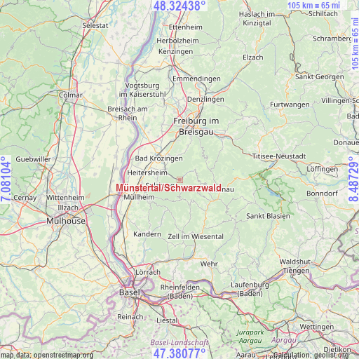
Münstertal/Schwarzwald GPS coordinates[2]
47° 51' 16.992" North, 7° 47' 3.012" East
| Map corner | latitude | longitude |
|---|---|---|
| Upper-left | 48.32438°, | 7.08104° |
| Center: | 47.85472°, | 7.78417° |
| Lower-right: | 47.38077°, | 8.48729° |
| Map W x H: | 104.9×104.9 km | = 65.2×65.2mi |
| max Lat: | 55.01917° ⇑97.1% North |
| Münstertal/Schwarzwald: | 47.85472° |
| min Lat: | ⇓2.9% South 47.40724° |
| min Long | Münstertal/Sch | max Long |
| 5.92978° | 7.78417° | 14.98853° |
| W 18.8%⇐ | ⇒81.2% E |
Elevation
Elevation of Münstertal/Schwarzwald is 381 m = 1250 ft, and this is 131.9 m = 433 ft above average elevation for this country.
| Max E: |
1256 m = 4121 ft | 27.2% |
| Münstertal/Schwarzwald | 381 m 1250 ft | |
| Avg. | 249.1 m = 817 ft | |
Min E: |
-5 m = -16 ft | 72.8% |
See also: Germany elevation on elevation.city.
Geographical zone
Münstertal/Schwarzwald is located in North temperate zone (between Tropic of Cancer and the Arctic Circle). Distance of this North polar circle is 2080.2 km =1292.6 mi to North.| Distance of | km | miles | from Münstertal/Schwarzwald |
|---|---|---|---|
| North Pole | 4686.1 | 2911.8 | to North |
| Arctic Circle | 2080.2 | 1292.6 | to North |
| Tropic Cancer | 2715 | 1687 | to South |
| Equator | 5320.9 | 3306.3 | to South |


Nearby cities:
15 places around Münstertal/Schwarzwald: (largest is in red/bold)
• Aitern
10.6 km =6.6 mi,  125°
125°
• Bad Krozingen
9.3 km =5.8 mi,  317°
317°
• Badenweiler
10.2 km =6.3 mi,  235°
235°
• Bollschweil
7.4 km =4.6 mi,  3°
3°
• Böllen
7.4 km =4.6 mi,  144°
144°
• Eschbach
10.4 km =6.5 mi,  292°
292°
• Heitersheim
9.7 km =6 mi,  283°
283°
• Horben
10.7 km =6.6 mi,  35°
35°
• Pfaffenweiler
9.1 km =5.7 mi,  343°
343°
• Schönenberg
10 km =6.2 mi, 132°
• Sulzburg
5.9 km =3.7 mi,  255°
255°
• Sölden
9.1 km =5.7 mi,  15°
15°
• Unterkrozingen
10 km =6.2 mi, 315°
• Wieden
7.4 km =4.6 mi,  101°
101°
• Wittnau
10.9 km =6.8 mi,  12°
12°
Sources, notices
• [Note1] Compared only with cities in Germany existing in our database
• [Src1] Map data: © OpenStreetMap contributors (CC-BY-SA)
• [Src2] Other city data from geonames.org with taken over terms of usage.
• [Src3] Geographical zone / Annual Mean Temperature by Robert A. Rohde @ Wikipedia
