Todtnau geodata
Todtnau (Baden-Württemberg) is a populated place; located in Germany in Europe/Berlin (GMT+2) time zone. With population of 5,072 people, there are 2799 cities with bigger population in this country. Compared to other cities in Germany, 97.3% of cities are located further ↑North; 78.2% of cities are located further →East and 96.5% of cities have lower elevation than Todtnau. Note1
Administrative division(s):
- Level 1: Baden-Württemberg
- Level 2: Freiburg Region
- Level 3: Landkreis Lörrach
- Level 4: Todtnau


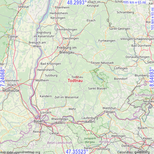
Todtnau GPS coordinates[2]
47° 49' 45.876" North, 7° 56' 37.68" East
| Map corner | latitude | longitude |
|---|---|---|
| Upper-left | 48.2993°, | 7.24068° |
| Center: | 47.82941°, | 7.9438° |
| Lower-right: | 47.35523°, | 8.64693° |
| Map W x H: | 105×105 km | = 65.2×65.2mi |
| max Lat: | 55.01917° ⇑97.3% North |
| Todtnau: | 47.82941° |
| min Lat: | ⇓2.7% South 47.40724° |
| min Long | Todtnau | max Long |
| 5.92978° | 7.9438° | 14.98853° |
| W 21.8%⇐ | ⇒78.2% E |
Elevation
Elevation of Todtnau is 642 m = 2106 ft, and this is 392.9 m = 1289 ft above average elevation for this country.
| Max E: |
1256 m = 4121 ft | 3.5% |
| Todtnau | 642 m 2106 ft | |
| Avg. | 249.1 m = 817 ft | |
Min E: |
-5 m = -16 ft | 96.5% |
See also: Germany elevation on elevation.city.
Geographical zone
Todtnau is located in North temperate zone (between Tropic of Cancer and the Arctic Circle). Distance of this North polar circle is 2083 km =1294.3 mi to North.| Distance of | km | miles | from Todtnau |
|---|---|---|---|
| North Pole | 4688.9 | 2913.5 | to North |
| Arctic Circle | 2083 | 1294.3 | to North |
| Tropic Cancer | 2712.2 | 1685.3 | to South |
| Equator | 5318.1 | 3304.5 | to South |


Nearby cities:
15 places around Todtnau: (largest is in red/bold)
• Aitern
4.6 km =2.9 mi,  225°
225°
• Bernau
7.8 km =4.8 mi,  114°
114°
• Böllen
8.3 km =5.2 mi,  246°
246°
• Hinterzarten
14.7 km =9.1 mi,  56°
56°
• Horben
12.9 km =8 mi,  333°
333°
• Ibach
14.1 km =8.8 mi,  139°
139°
• Münstertal/Schwarzwald
12.2 km =7.6 mi,  283°
283°
• Oberried
11.6 km =7.2 mi,  2°
2°
• Schönau im Schwarzwald
6.1 km =3.8 mi,  217°
217°
• Schönenberg
6.1 km =3.8 mi, 229°
• Todtmoos
10.8 km =6.7 mi,  156°
156°
• Tunau
5 km =3.1 mi,  196°
196°
• Utzenfeld
3.8 km =2.4 mi,  211°
211°
• Wembach
7.6 km =4.7 mi, 213°
• Wieden
4.8 km =3 mi,  286°
286°
Sources, notices
• [Note1] Compared only with cities in Germany existing in our database
• [Src1] Map data: © OpenStreetMap contributors (CC-BY-SA)
• [Src2] Other city data from geonames.org with taken over terms of usage.
• [Src3] Geographical zone / Annual Mean Temperature by Robert A. Rohde @ Wikipedia
