Boizenburg geodata
Boizenburg (Mecklenburg-Vorpommern) is a populated place; located in Germany in Europe/Berlin (GMT+2) time zone. With population of 10,783 people, there are 1532 cities with bigger population in this country. Compared to other cities in Germany, 84.3% of cities are located further ↓South; 62.9% of cities are located further ←West and 84.5% of cities have higher elevation than Boizenburg. Note1
Administrative division(s):
- Level 1: Mecklenburg-Vorpommern
- Level 3: Ludwigslust-Parchim
- Level 4: Boizenburg/ Elbe


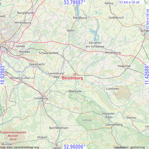
Boizenburg GPS coordinates[2]
53° 22' 53.508" North, 10° 43' 25.5" East
| Map corner | latitude | longitude |
|---|---|---|
| Upper-left | 53.79887°, | 10.02063° |
| Center: | 53.38153°, | 10.72375° |
| Lower-right: | 52.96006°, | 11.42688° |
| Map W x H: | 93.3×93.3 km | = 58×58mi |
| max Lat: | 55.01917° ⇑15.7% North |
| Boizenburg: | 53.38153° |
| min Lat: | ⇓84.3% South 47.40724° |
| min Long | Boizenburg | max Long |
| 5.92978° | 10.72375° | 14.98853° |
| W 62.9%⇐ | ⇒37.1% E |
Elevation
Elevation of Boizenburg is 36 m = 118 ft, and this is 213.1 m = 699 ft below average elevation for this country.
| Max E: |
1256 m = 4121 ft | 84.5% |
| Avg. | 249.1 m = 817 ft | |
| Boizenburg | 36 m = 118 ft | |
Min E: |
-5 m = -16 ft | 15.5% |
See also: Germany elevation on elevation.city.
Geographical zone
Boizenburg is located in North temperate zone (between Tropic of Cancer and the Arctic Circle). Distance of this North polar circle is 1465.7 km =910.7 mi to North.| Distance of | km | miles | from Boizenburg |
|---|---|---|---|
| North Pole | 4071.6 | 2530 | to North |
| Arctic Circle | 1465.7 | 910.7 | to North |
| Tropic Cancer | 3329.6 | 2068.9 | to South |
| Equator | 5935.5 | 3688.1 | to South |


Nearby cities:
15 places around Boizenburg: (largest is in red/bold)
• Basedow
10.1 km =6.3 mi,  292°
292°
• Besitz
10 km =6.2 mi,  115°
115°
• Bleckede
10.2 km =6.3 mi,  176°
176°
• Bröthen
11.5 km =7.1 mi,  341°
341°
• Buchhorst
10.5 km =6.5 mi,  272°
272°
• Dalldorf
9.5 km =5.9 mi,  308°
308°
• Gresse
5.5 km =3.4 mi,  15°
15°
• Hittbergen
9.8 km =6.1 mi,  245°
245°
• Lanze
7.9 km =4.9 mi, 274°
• Lauenburg
11.1 km =6.9 mi,  264°
264°
• Lüdersburg
12 km =7.5 mi,  236°
236°
• Neu Gülze
4.3 km =2.7 mi,  92°
92°
• Nostorf
5.4 km =3.4 mi,  301°
301°
• Schwanheide
5.9 km =3.7 mi,  333°
333°
• Witzeeze
10.9 km =6.8 mi,  315°
315°
In other languages:
- In German: Boizenburg/Elbe
- In Italian: Boizenburg/ Elbe
- In Russian: Бойценбург
- In Chinese: 博伊岑堡
Sources, notices
• [Note1] Compared only with cities in Germany existing in our database
• [Src1] Map data: © OpenStreetMap contributors (CC-BY-SA)
• [Src2] Other city data from geonames.org with taken over terms of usage.
• [Src3] Geographical zone / Annual Mean Temperature by Robert A. Rohde @ Wikipedia
