Blender geodata
Blender (Lower Saxony) is a seat of a fourth-order administrative division; located in Germany in Europe/Berlin (GMT+2) time zone. With population of 2,954 people, there are 4043 cities with bigger population in this country. Compared to other cities in Germany, 81.2% of cities are located further ↓South; 63.5% of cities are located further →East and 93.9% of cities have higher elevation than Blender. Note1


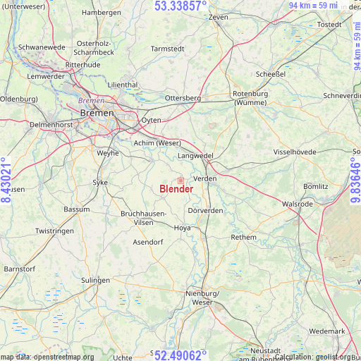
Blender GPS coordinates[2]
52° 55' 0.012" North, 9° 7' 59.988" East
| Map corner | latitude | longitude |
|---|---|---|
| Upper-left | 53.33857°, | 8.43021° |
| Center: | 52.91667°, | 9.13333° |
| Lower-right: | 52.49062°, | 9.83646° |
| Map W x H: | 94.3×94.3 km | = 58.6×58.6mi |
| max Lat: | 55.01917° ⇑18.8% North |
| Blender: | 52.91667° |
| min Lat: | ⇓81.2% South 47.40724° |
| min Long | Blender | max Long |
| 5.92978° | 9.13333° | 14.98853° |
| W 36.5%⇐ | ⇒63.5% E |
Elevation
Elevation of Blender is 11 m = 36 ft, and this is 238.1 m = 781 ft below average elevation for this country.
| Max E: |
1256 m = 4121 ft | 93.9% |
| Avg. | 249.1 m = 817 ft | |
| Blender | 11 m = 36 ft | |
Min E: |
-5 m = -16 ft | 6.1% |
See also: Germany elevation on elevation.city.
Geographical zone
Blender is located in North temperate zone (between Tropic of Cancer and the Arctic Circle). Distance of this North polar circle is 1517.4 km =942.9 mi to North.| Distance of | km | miles | from Blender |
|---|---|---|---|
| North Pole | 4123.3 | 2562.1 | to North |
| Arctic Circle | 1517.4 | 942.9 | to North |
| Tropic Cancer | 3277.9 | 2036.8 | to South |
| Equator | 5883.8 | 3656 | to South |


Nearby cities:
15 places around Blender: (largest is in red/bold)
• Achim
13 km =8.1 mi,  326°
326°
• Ahsen-Oetzen
5.9 km =3.7 mi,  322°
322°
• Dörverden
10 km =6.2 mi,  137°
137°
• Emtinghausen
11.3 km =7 mi,  279°
279°
• Hilgermissen
7.7 km =4.8 mi,  163°
163°
• Hoya
12.1 km =7.5 mi,  177°
177°
• Hoyerhagen
9.9 km =6.2 mi,  199°
199°
• Kirchlinteln
12.7 km =7.9 mi,  77°
77°
• Langwedel
7.7 km =4.8 mi,  26°
26°
• Martfeld
6.7 km =4.2 mi,  226°
226°
• Morsum
5.4 km =3.4 mi, 318°
• Scharnhorst
10.4 km =6.5 mi,  66°
66°
• Schwarme
8 km =5 mi,  256°
256°
• Thedinghausen
9.6 km =6 mi,  305°
305°
• Verden
6.9 km =4.3 mi, 83°
Sources, notices
• [Note1] Compared only with cities in Germany existing in our database
• [Src1] Map data: © OpenStreetMap contributors (CC-BY-SA)
• [Src2] Other city data from geonames.org with taken over terms of usage.
• [Src3] Geographical zone / Annual Mean Temperature by Robert A. Rohde @ Wikipedia
