Martfeld geodata
Martfeld (Lower Saxony) is a seat of a fourth-order administrative division; located in Germany in Europe/Berlin (GMT+2) time zone. With population of 2,867 people, there are 4126 cities with bigger population in this country. Compared to other cities in Germany, 80.9% of cities are located further ↓South; 64.6% of cities are located further →East and 92.7% of cities have higher elevation than Martfeld. Note1


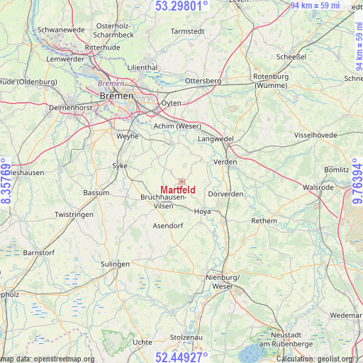
Martfeld GPS coordinates[2]
52° 52' 32.592" North, 9° 3' 38.916" East
| Map corner | latitude | longitude |
|---|---|---|
| Upper-left | 53.29801°, | 8.35769° |
| Center: | 52.87572°, | 9.06081° |
| Lower-right: | 52.44927°, | 9.76394° |
| Map W x H: | 94.4×94.4 km | = 58.7×58.7mi |
| max Lat: | 55.01917° ⇑19.1% North |
| Martfeld: | 52.87572° |
| min Lat: | ⇓80.9% South 47.40724° |
| min Long | Martfeld | max Long |
| 5.92978° | 9.06081° | 14.98853° |
| W 35.4%⇐ | ⇒64.6% E |
Elevation
Elevation of Martfeld is 14 m = 46 ft, and this is 235.1 m = 771 ft below average elevation for this country.
| Max E: |
1256 m = 4121 ft | 92.7% |
| Avg. | 249.1 m = 817 ft | |
| Martfeld | 14 m = 46 ft | |
Min E: |
-5 m = -16 ft | 7.3% |
See also: Germany elevation on elevation.city.
Geographical zone
Martfeld is located in North temperate zone (between Tropic of Cancer and the Arctic Circle). Distance of this North polar circle is 1521.9 km =945.7 mi to North.| Distance of | km | miles | from Martfeld |
|---|---|---|---|
| North Pole | 4127.8 | 2564.9 | to North |
| Arctic Circle | 1521.9 | 945.7 | to North |
| Tropic Cancer | 3273.3 | 2033.9 | to South |
| Equator | 5879.2 | 3653.2 | to South |


Nearby cities:
15 places around Martfeld: (largest is in red/bold)
• Ahsen-Oetzen
9.3 km =5.8 mi,  7°
7°
• Asendorf
12.1 km =7.5 mi,  198°
198°
• Blender
6.7 km =4.2 mi,  46°
46°
• Bruchhausen-Vilsen
7 km =4.3 mi,  222°
222°
• Bücken
11.8 km =7.3 mi,  155°
155°
• Dörverden
11.9 km =7.4 mi,  103°
103°
• Emtinghausen
9 km =5.6 mi,  315°
315°
• Hilgermissen
7.7 km =4.8 mi,  111°
111°
• Hoya
9.2 km =5.7 mi,  144°
144°
• Hoyerhagen
4.9 km =3 mi, 162°
• Morsum
8.7 km =5.4 mi, 8°
• Riede
12.5 km =7.8 mi, 323°
• Schwarme
4 km =2.5 mi,  312°
312°
• Süstedt
9.4 km =5.8 mi,  260°
260°
• Thedinghausen
10.5 km =6.5 mi,  343°
343°
Sources, notices
• [Note1] Compared only with cities in Germany existing in our database
• [Src1] Map data: © OpenStreetMap contributors (CC-BY-SA)
• [Src2] Other city data from geonames.org with taken over terms of usage.
• [Src3] Geographical zone / Annual Mean Temperature by Robert A. Rohde @ Wikipedia
