Hoyerhagen geodata
Hoyerhagen (Lower Saxony) is a seat of a fourth-order administrative division; located in Germany in Europe/Berlin (GMT+2) time zone. With population of 1,000 people, there are 7180 cities with bigger population in this country. Compared to other cities in Germany, 80.6% of cities are located further ↓South; 64.2% of cities are located further →East and 92% of cities have higher elevation than Hoyerhagen. Note1
Administrative division(s):
- Level 1: Lower Saxony
- Level 3: Landkreis Nienburg/Weser
- Level 4: Hoyerhagen


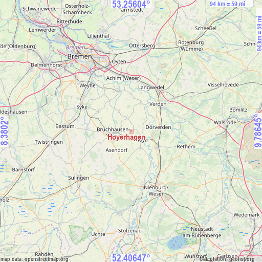
Hoyerhagen GPS coordinates[2]
52° 49' 59.988" North, 9° 4' 59.988" East
| Map corner | latitude | longitude |
|---|---|---|
| Upper-left | 53.25604°, | 8.3802° |
| Center: | 52.83333°, | 9.08333° |
| Lower-right: | 52.40647°, | 9.78645° |
| Map W x H: | 94.5×94.5 km | = 58.7×58.7mi |
| max Lat: | 55.01917° ⇑19.4% North |
| Hoyerhagen: | 52.83333° |
| min Lat: | ⇓80.6% South 47.40724° |
| min Long | Hoyerhagen | max Long |
| 5.92978° | 9.08333° | 14.98853° |
| W 35.8%⇐ | ⇒64.2% E |
Elevation
Elevation of Hoyerhagen is 16 m = 52 ft, and this is 233.1 m = 765 ft below average elevation for this country.
| Max E: |
1256 m = 4121 ft | 92% |
| Avg. | 249.1 m = 817 ft | |
| Hoyerhagen | 16 m = 52 ft | |
Min E: |
-5 m = -16 ft | 8% |
See also: Germany elevation on elevation.city.
Geographical zone
Hoyerhagen is located in North temperate zone (between Tropic of Cancer and the Arctic Circle). Distance of this North polar circle is 1526.7 km =948.6 mi to North.| Distance of | km | miles | from Hoyerhagen |
|---|---|---|---|
| North Pole | 4132.5 | 2567.8 | to North |
| Arctic Circle | 1526.7 | 948.6 | to North |
| Tropic Cancer | 3268.6 | 2031 | to South |
| Equator | 5874.5 | 3650.2 | to South |


Nearby cities:
15 places around Hoyerhagen: (largest is in red/bold)
• Asendorf
8.6 km =5.3 mi,  217°
217°
• Blender
9.9 km =6.2 mi,  19°
19°
• Bruchhausen-Vilsen
6.2 km =3.9 mi,  265°
265°
• Bücken
6.9 km =4.3 mi,  150°
150°
• Dörverden
10.2 km =6.3 mi,  79°
79°
• Engeln
11.9 km =7.4 mi,  248°
248°
• Eystrup
10.6 km =6.6 mi,  124°
124°
• Gandesbergen
12.6 km =7.8 mi,  130°
130°
• Hilgermissen
5.9 km =3.7 mi,  71°
71°
• Hoya
4.8 km =3 mi, 126°
• Martfeld
4.9 km =3 mi,  342°
342°
• Schwarme
8.7 km =5.4 mi,  328°
328°
• Schweringen
11.4 km =7.1 mi,  144°
144°
• Süstedt
11.3 km =7 mi,  286°
286°
• Warpe
11.2 km =7 mi,  174°
174°
Sources, notices
• [Note1] Compared only with cities in Germany existing in our database
• [Src1] Map data: © OpenStreetMap contributors (CC-BY-SA)
• [Src2] Other city data from geonames.org with taken over terms of usage.
• [Src3] Geographical zone / Annual Mean Temperature by Robert A. Rohde @ Wikipedia
