Langwedel geodata
Langwedel (Lower Saxony) is a populated place; located in Germany in Europe/Berlin (GMT+2) time zone. With population of 14,755 people, there are 1078 cities with bigger population in this country. Compared to other cities in Germany, 81.6% of cities are located further ↓South; 62.6% of cities are located further →East and 93.5% of cities have higher elevation than Langwedel. Note1
Administrative division(s):
- Level 1: Lower Saxony
- Level 3: Landkreis Verden
- Level 4: Langwedel, Flecken


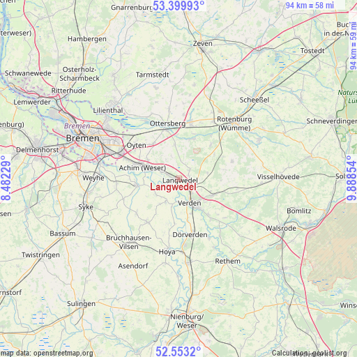
Langwedel GPS coordinates[2]
52° 58' 43.104" North, 9° 11' 7.512" East
| Map corner | latitude | longitude |
|---|---|---|
| Upper-left | 53.39993°, | 8.48229° |
| Center: | 52.97864°, | 9.18542° |
| Lower-right: | 52.5532°, | 9.88854° |
| Map W x H: | 94.1×94.1 km | = 58.5×58.5mi |
| max Lat: | 55.01917° ⇑18.4% North |
| Langwedel: | 52.97864° |
| min Lat: | ⇓81.6% South 47.40724° |
| min Long | Langwedel | max Long |
| 5.92978° | 9.18542° | 14.98853° |
| W 37.4%⇐ | ⇒62.6% E |
Elevation
Elevation of Langwedel is 12 m = 39 ft, and this is 237.1 m = 778 ft below average elevation for this country.
| Max E: |
1256 m = 4121 ft | 93.5% |
| Avg. | 249.1 m = 817 ft | |
| Langwedel | 12 m = 39 ft | |
Min E: |
-5 m = -16 ft | 6.5% |
See also: Germany elevation on elevation.city.
Geographical zone
Langwedel is located in North temperate zone (between Tropic of Cancer and the Arctic Circle). Distance of this North polar circle is 1510.5 km =938.6 mi to North.| Distance of | km | miles | from Langwedel |
|---|---|---|---|
| North Pole | 4116.4 | 2557.8 | to North |
| Arctic Circle | 1510.5 | 938.6 | to North |
| Tropic Cancer | 3284.8 | 2041.1 | to South |
| Equator | 5890.7 | 3660.3 | to South |


Nearby cities:
15 places around Langwedel: (largest is in red/bold)
• Achim
11.4 km =7.1 mi,  290°
290°
• Ahausen
13.1 km =8.1 mi,  41°
41°
• Ahsen-Oetzen
7.4 km =4.6 mi,  252°
252°
• Blender
7.7 km =4.8 mi,  206°
206°
• Hellwege
11.1 km =6.9 mi,  17°
17°
• Hilgermissen
14.4 km =8.9 mi,  185°
185°
• Kirchlinteln
9.8 km =6.1 mi,  114°
114°
• Martfeld
14.2 km =8.8 mi,  216°
216°
• Morsum
7.6 km =4.7 mi, 248°
• Oyten
13.8 km =8.6 mi,  305°
305°
• Scharnhorst
6.6 km =4.1 mi, 114°
• Schwarme
14.3 km =8.9 mi,  232°
232°
• Thedinghausen
11.4 km =7.1 mi,  263°
263°
• Verden
7 km =4.3 mi,  151°
151°
• Westerwalsede
13.6 km =8.5 mi,  63°
63°
Sources, notices
• [Note1] Compared only with cities in Germany existing in our database
• [Src1] Map data: © OpenStreetMap contributors (CC-BY-SA)
• [Src2] Other city data from geonames.org with taken over terms of usage.
• [Src3] Geographical zone / Annual Mean Temperature by Robert A. Rohde @ Wikipedia
