Biesdorf geodata
Biesdorf (Berlin) is a section of populated place; located in Germany in Europe/Berlin (GMT+2) time zone. With population of 24,988 people, there are 592 cities with bigger population in this country. Compared to other cities in Germany, 77.5% of cities are located further ↓South; 96.1% of cities are located further ←West and 81% of cities have higher elevation than Biesdorf. Note1


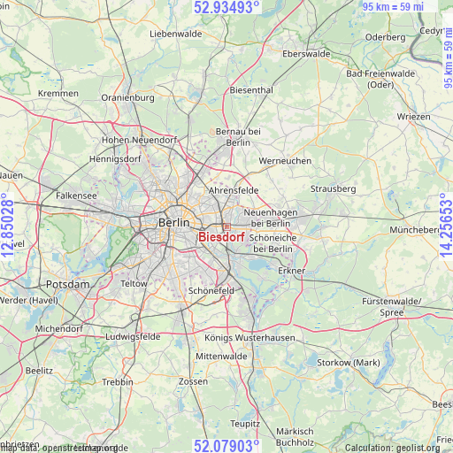
Biesdorf GPS coordinates[2]
52° 30' 32.616" North, 13° 33' 12.24" East
| Map corner | latitude | longitude |
|---|---|---|
| Upper-left | 52.93493°, | 12.85028° |
| Center: | 52.50906°, | 13.5534° |
| Lower-right: | 52.07903°, | 14.25653° |
| Map W x H: | 95.2×95.2 km | = 59.2×59.2mi |
| max Lat: | 55.01917° ⇑22.5% North |
| Biesdorf: | 52.50906° |
| min Lat: | ⇓77.5% South 47.40724° |
| min Long | Biesdorf | max Long |
| 5.92978° | 13.5534° | 14.98853° |
| W 96.1%⇐ | ⇒3.9% E |
Elevation
Elevation of Biesdorf is 44 m = 144 ft, and this is 205.1 m = 673 ft below average elevation for this country.
| Max E: |
1256 m = 4121 ft | 81% |
| Avg. | 249.1 m = 817 ft | |
| Biesdorf | 44 m = 144 ft | |
Min E: |
-5 m = -16 ft | 19% |
See also: Germany elevation on elevation.city.
Geographical zone
Biesdorf is located in North temperate zone (between Tropic of Cancer and the Arctic Circle). Distance of this North polar circle is 1562.7 km =971 mi to North.| Distance of | km | miles | from Biesdorf |
|---|---|---|---|
| North Pole | 4168.6 | 2590.2 | to North |
| Arctic Circle | 1562.7 | 971 | to North |
| Tropic Cancer | 3232.5 | 2008.6 | to South |
| Equator | 5838.5 | 3627.9 | to South |


Nearby cities:
15 places around Biesdorf: (largest is in red/bold)
• Alt-Hohenschönhausen
5.4 km =3.4 mi,  319°
319°
• Baumschulenweg
6.7 km =4.2 mi,  223°
223°
• Falkenberg
6.6 km =4.1 mi,  355°
355°
• Fennpfuhl
5.9 km =3.7 mi,  292°
292°
• Friedrichsfelde
3.1 km =1.9 mi,  263°
263°
• Hellersdorf
4.6 km =2.9 mi,  54°
54°
• Karlshorst
3.1 km =1.9 mi,  207°
207°
• Kaulsdorf
2.6 km =1.6 mi,  68°
68°
• Lichtenberg
3.7 km =2.3 mi,  278°
278°
• Mahlsdorf
4.1 km =2.5 mi,  89°
89°
• Marzahn
4.2 km =2.6 mi,  15°
15°
• Niederschöneweide
6.5 km =4 mi,  203°
203°
• Oberschöneweide
5.8 km =3.6 mi, 202°
• Plänterwald
6.3 km =3.9 mi,  240°
240°
• Rummelsburg
4.1 km =2.5 mi, 258°
Sources, notices
• [Note1] Compared only with cities in Germany existing in our database
• [Src1] Map data: © OpenStreetMap contributors (CC-BY-SA)
• [Src2] Other city data from geonames.org with taken over terms of usage.
• [Src3] Geographical zone / Annual Mean Temperature by Robert A. Rohde @ Wikipedia
