Bichl geodata
Bichl (Bavaria) is a seat of a fourth-order administrative division; located in Germany in Europe/Berlin (GMT+2) time zone. With population of 2,007 people, there are 5059 cities with bigger population in this country. Compared to other cities in Germany, 98.6% of cities are located further ↑North; 72.8% of cities are located further ←West and 95.9% of cities have lower elevation than Bichl. Note1
Administrative division(s):
- Level 1: Bavaria
- Level 2: Upper Bavaria
- Level 3: Landkreis Bad Tölz-Wolfratshausen
- Level 4: Bichl


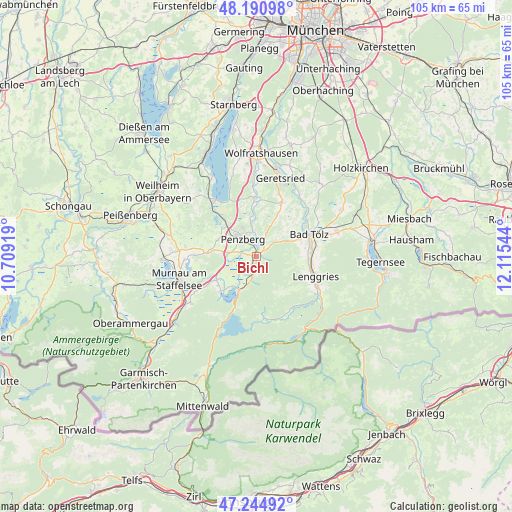
Bichl GPS coordinates[2]
47° 43' 12.36" North, 11° 24' 44.316" East
| Map corner | latitude | longitude |
|---|---|---|
| Upper-left | 48.19098°, | 10.70919° |
| Center: | 47.7201°, | 11.41231° |
| Lower-right: | 47.24492°, | 12.11544° |
| Map W x H: | 105.2×105.2 km | = 65.4×65.4mi |
| max Lat: | 55.01917° ⇑98.6% North |
| Bichl: | 47.7201° |
| min Lat: | ⇓1.4% South 47.40724° |
| min Long | Bichl | max Long |
| 5.92978° | 11.41231° | 14.98853° |
| W 72.8%⇐ | ⇒27.2% E |
Elevation
Elevation of Bichl is 625 m = 2051 ft, and this is 375.9 m = 1233 ft above average elevation for this country.
| Max E: |
1256 m = 4121 ft | 4.1% |
| Bichl | 625 m 2051 ft | |
| Avg. | 249.1 m = 817 ft | |
Min E: |
-5 m = -16 ft | 95.9% |
See also: Germany elevation on elevation.city.
Geographical zone
Bichl is located in North temperate zone (between Tropic of Cancer and the Arctic Circle). Distance of this North polar circle is 2095.2 km =1301.9 mi to North.| Distance of | km | miles | from Bichl |
|---|---|---|---|
| North Pole | 4701.1 | 2921.1 | to North |
| Arctic Circle | 2095.2 | 1301.9 | to North |
| Tropic Cancer | 2700.1 | 1677.8 | to South |
| Equator | 5306 | 3297 | to South |


Nearby cities:
15 places around Bichl: (largest is in red/bold)
• Antdorf
8.5 km =5.3 mi,  294°
294°
• Bad Heilbrunn
4.6 km =2.9 mi,  49°
49°
• Bad Tölz
11.9 km =7.4 mi,  67°
67°
• Benediktbeuern
1.6 km =1 mi,  171°
171°
• Großweil
9.7 km =6 mi,  239°
239°
• Habach
9.8 km =6.1 mi,  278°
278°
• Iffeldorf
8.8 km =5.5 mi,  305°
305°
• Kochel
7.5 km =4.7 mi,  205°
205°
• Kreut
10.2 km =6.3 mi,  31°
31°
• Königsdorf
11.8 km =7.3 mi, 25°
• Lenggries
12.3 km =7.6 mi,  109°
109°
• Penzberg
4.5 km =2.8 mi,  324°
324°
• Schlehdorf
10 km =6.2 mi,  226°
226°
• Sindelsdorf
6 km =3.7 mi,  274°
274°
• Wackersberg
10.4 km =6.5 mi,  81°
81°
Sources, notices
• [Note1] Compared only with cities in Germany existing in our database
• [Src1] Map data: © OpenStreetMap contributors (CC-BY-SA)
• [Src2] Other city data from geonames.org with taken over terms of usage.
• [Src3] Geographical zone / Annual Mean Temperature by Robert A. Rohde @ Wikipedia
