Ballendorf geodata
Ballendorf (Baden-Württemberg) is a seat of a fourth-order administrative division; located in Germany in Europe/Berlin (GMT+2) time zone. With population of 651 people, there are 8551 cities with bigger population in this country. Compared to other cities in Germany, 88.4% of cities are located further ↑North; 51.3% of cities are located further ←West and 92.3% of cities have lower elevation than Ballendorf. Note1
Administrative division(s):
- Level 1: Baden-Württemberg
- Level 2: Tübingen Region
- Level 3: Alb-Donau-Kreis
- Level 4: Ballendorf


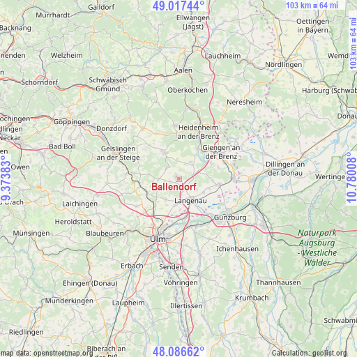
Ballendorf GPS coordinates[2]
48° 33' 15.012" North, 10° 4' 37.02" East
| Map corner | latitude | longitude |
|---|---|---|
| Upper-left | 49.01744°, | 9.37383° |
| Center: | 48.55417°, | 10.07695° |
| Lower-right: | 48.08662°, | 10.78008° |
| Map W x H: | 103.5×103.5 km | = 64.3×64.3mi |
| max Lat: | 55.01917° ⇑88.4% North |
| Ballendorf: | 48.55417° |
| min Lat: | ⇓11.6% South 47.40724° |
| min Long | Ballendorf | max Long |
| 5.92978° | 10.07695° | 14.98853° |
| W 51.3%⇐ | ⇒48.7% E |
Elevation
Elevation of Ballendorf is 546 m = 1791 ft, and this is 296.9 m = 974 ft above average elevation for this country.
| Max E: |
1256 m = 4121 ft | 7.7% |
| Ballendorf | 546 m 1791 ft | |
| Avg. | 249.1 m = 817 ft | |
Min E: |
-5 m = -16 ft | 92.3% |
See also: Germany elevation on elevation.city.
Geographical zone
Ballendorf is located in North temperate zone (between Tropic of Cancer and the Arctic Circle). Distance of this North polar circle is 2002.5 km =1244.3 mi to North.| Distance of | km | miles | from Ballendorf |
|---|---|---|---|
| North Pole | 4608.3 | 2863.5 | to North |
| Arctic Circle | 2002.5 | 1244.3 | to North |
| Tropic Cancer | 2792.8 | 1735.4 | to South |
| Equator | 5398.7 | 3354.6 | to South |


Nearby cities:
15 places around Ballendorf: (largest is in red/bold)
• Asselfingen
8.9 km =5.5 mi,  107°
107°
• Bernstadt
7.1 km =4.4 mi,  211°
211°
• Bolheim
10.1 km =6.3 mi,  32°
32°
• Breitingen
7.5 km =4.7 mi,  236°
236°
• Börslingen
2 km =1.2 mi, 210°
• Gerstetten
8.7 km =5.4 mi,  331°
331°
• Holzkirch
6.5 km =4 mi,  247°
247°
• Langenau
7.1 km =4.4 mi,  154°
154°
• Neenstetten
4.3 km =2.7 mi,  258°
258°
• Nerenstetten
3.3 km =2.1 mi, 149°
• Rammingen
8.1 km =5 mi,  119°
119°
• Setzingen
4.3 km =2.7 mi, 114°
• Weidenstetten
6 km =3.7 mi,  268°
268°
• Westerstetten
9.8 km =6.1 mi, 246°
• Öllingen
5.9 km =3.7 mi, 118°
Sources, notices
• [Note1] Compared only with cities in Germany existing in our database
• [Src1] Map data: © OpenStreetMap contributors (CC-BY-SA)
• [Src2] Other city data from geonames.org with taken over terms of usage.
• [Src3] Geographical zone / Annual Mean Temperature by Robert A. Rohde @ Wikipedia
