Bolheim geodata
Bolheim (Baden-Württemberg) is a populated place; located in Germany in Europe/Berlin (GMT+2) time zone. With population of 3,180 people, there are 3846 cities with bigger population in this country. Compared to other cities in Germany, 87.4% of cities are located further ↑North; 52.4% of cities are located further ←West and 86.7% of cities have lower elevation than Bolheim. Note1
Administrative division(s):
- Level 1: Baden-Württemberg
- Level 2: Regierungsbezirk Stuttgart
- Level 3: Landkreis Heidenheim
- Level 4: Herbrechtingen


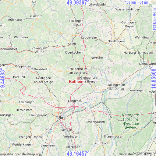
Bolheim GPS coordinates[2]
48° 37' 53.076" North, 10° 8' 59.82" East
| Map corner | latitude | longitude |
|---|---|---|
| Upper-left | 49.09397°, | 9.44683° |
| Center: | 48.63141°, | 10.14995° |
| Lower-right: | 48.16457°, | 10.85308° |
| Map W x H: | 103.3×103.3 km | = 64.2×64.2mi |
| max Lat: | 55.01917° ⇑87.4% North |
| Bolheim: | 48.63141° |
| min Lat: | ⇓12.6% South 47.40724° |
| min Long | Bolheim | max Long |
| 5.92978° | 10.14995° | 14.98853° |
| W 52.4%⇐ | ⇒47.6% E |
Elevation
Elevation of Bolheim is 483 m = 1585 ft, and this is 233.9 m = 767 ft above average elevation for this country.
| Max E: |
1256 m = 4121 ft | 13.3% |
| Bolheim | 483 m 1585 ft | |
| Avg. | 249.1 m = 817 ft | |
Min E: |
-5 m = -16 ft | 86.7% |
See also: Germany elevation on elevation.city.
Geographical zone
Bolheim is located in North temperate zone (between Tropic of Cancer and the Arctic Circle). Distance of this North polar circle is 1993.9 km =1239 mi to North.| Distance of | km | miles | from Bolheim |
|---|---|---|---|
| North Pole | 4599.8 | 2858.2 | to North |
| Arctic Circle | 1993.9 | 1239 | to North |
| Tropic Cancer | 2801.4 | 1740.7 | to South |
| Equator | 5407.3 | 3359.9 | to South |


Nearby cities:
15 places around Bolheim: (largest is in red/bold)
• Asselfingen
11.7 km =7.3 mi,  164°
164°
• Bachhagel
12.5 km =7.8 mi,  89°
89°
• Ballendorf
10.1 km =6.3 mi,  212°
212°
• Börslingen
12.1 km =7.5 mi, 211°
• Gerstetten
9.6 km =6 mi,  264°
264°
• Giengen an der Brenz
6.9 km =4.3 mi,  98°
98°
• Heidenheim an der Brenz
5.2 km =3.2 mi,  1°
1°
• Herbrechtingen
2.2 km =1.4 mi,  119°
119°
• Hermaringen
9.1 km =5.7 mi, 116°
• Nattheim
10.2 km =6.3 mi,  41°
41°
• Nerenstetten
12 km =7.5 mi,  198°
198°
• Niederstotzingen
11.8 km =7.3 mi,  148°
148°
• Setzingen
10.5 km =6.5 mi,  187°
187°
• Steinheim am Albuch
9.2 km =5.7 mi,  316°
316°
• Öllingen
11.4 km =7.1 mi,  180°
180°
Sources, notices
• [Note1] Compared only with cities in Germany existing in our database
• [Src1] Map data: © OpenStreetMap contributors (CC-BY-SA)
• [Src2] Other city data from geonames.org with taken over terms of usage.
• [Src3] Geographical zone / Annual Mean Temperature by Robert A. Rohde @ Wikipedia
