Bad Waldsee geodata
Bad Waldsee (Baden-Württemberg) is a populated place; located in Germany in Europe/Berlin (GMT+2) time zone. With population of 19,840 people, there are 786 cities with bigger population in this country. Compared to other cities in Germany, 96.4% of cities are located further ↑North; 53.5% of cities are located further →East and 94.6% of cities have lower elevation than Bad Waldsee. Note1
Administrative division(s):
- Level 1: Baden-Württemberg
- Level 2: Tübingen Region
- Level 3: Landkreis Ravensburg
- Level 4: Bad Waldsee


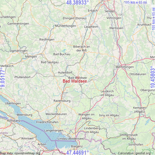
Bad Waldsee GPS coordinates[2]
47° 55' 12.972" North, 9° 45' 17.64" East
| Map corner | latitude | longitude |
|---|---|---|
| Upper-left | 48.38933°, | 9.05177° |
| Center: | 47.92027°, | 9.7549° |
| Lower-right: | 47.44691°, | 10.45803° |
| Map W x H: | 104.8×104.8 km | = 65.1×65.1mi |
| max Lat: | 55.01917° ⇑96.4% North |
| Bad Waldsee: | 47.92027° |
| min Lat: | ⇓3.6% South 47.40724° |
| min Long | Bad Waldsee | max Long |
| 5.92978° | 9.7549° | 14.98853° |
| W 46.5%⇐ | ⇒53.5% E |
Elevation
Elevation of Bad Waldsee is 590 m = 1936 ft, and this is 340.9 m = 1118 ft above average elevation for this country.
| Max E: |
1256 m = 4121 ft | 5.4% |
| Bad Waldsee | 590 m 1936 ft | |
| Avg. | 249.1 m = 817 ft | |
Min E: |
-5 m = -16 ft | 94.6% |
See also: Germany elevation on elevation.city.
Geographical zone
Bad Waldsee is located in North temperate zone (between Tropic of Cancer and the Arctic Circle). Distance of this North polar circle is 2072.9 km =1288 mi to North.| Distance of | km | miles | from Bad Waldsee |
|---|---|---|---|
| North Pole | 4678.8 | 2907.3 | to North |
| Arctic Circle | 2072.9 | 1288 | to North |
| Tropic Cancer | 2722.3 | 1691.6 | to South |
| Equator | 5328.2 | 3310.8 | to South |


Nearby cities:
15 places around Bad Waldsee: (largest is in red/bold)
• Aulendorf
9.4 km =5.8 mi,  291°
291°
• Bad Schussenried
11.9 km =7.4 mi,  322°
322°
• Bad Wurzach
10.7 km =6.6 mi,  97°
97°
• Baienfurt
12.8 km =8 mi,  217°
217°
• Baindt
10.2 km =6.3 mi, 220°
• Berg
16.3 km =10.1 mi,  225°
225°
• Bergatreute
7.8 km =4.8 mi,  182°
182°
• Eberhardzell
10 km =6.2 mi,  27°
27°
• Ebersbach-Musbach
13.8 km =8.6 mi, 291°
• Fronreute
14.9 km =9.3 mi,  248°
248°
• Hochdorf
12 km =7.5 mi,  11°
11°
• Ingoldingen
11.7 km =7.3 mi,  355°
355°
• Weingarten
15 km =9.3 mi, 215°
• Wolfegg
11.5 km =7.1 mi,  164°
164°
• Wolpertswende
11 km =6.8 mi,  255°
255°
Sources, notices
• [Note1] Compared only with cities in Germany existing in our database
• [Src1] Map data: © OpenStreetMap contributors (CC-BY-SA)
• [Src2] Other city data from geonames.org with taken over terms of usage.
• [Src3] Geographical zone / Annual Mean Temperature by Robert A. Rohde @ Wikipedia
