Ingoldingen geodata
Ingoldingen (Baden-Württemberg) is a seat of a fourth-order administrative division; located in Germany in Europe/Berlin (GMT+2) time zone. With population of 2,632 people, there are 4305 cities with bigger population in this country. Compared to other cities in Germany, 95.2% of cities are located further ↑North; 53.7% of cities are located further →East and 93.1% of cities have lower elevation than Ingoldingen. Note1
Administrative division(s):
- Level 1: Baden-Württemberg
- Level 2: Tübingen Region
- Level 3: Landkreis Biberach
- Level 4: Ingoldingen


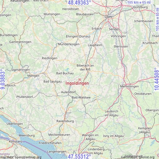
Ingoldingen GPS coordinates[2]
48° 1' 31.872" North, 9° 44' 31.02" East
| Map corner | latitude | longitude |
|---|---|---|
| Upper-left | 48.49363°, | 9.03883° |
| Center: | 48.02552°, | 9.74195° |
| Lower-right: | 47.55312°, | 10.44508° |
| Map W x H: | 104.6×104.6 km | = 65×65mi |
| max Lat: | 55.01917° ⇑95.2% North |
| Ingoldingen: | 48.02552° |
| min Lat: | ⇓4.8% South 47.40724° |
| min Long | Ingoldingen | max Long |
| 5.92978° | 9.74195° | 14.98853° |
| W 46.3%⇐ | ⇒53.7% E |
Elevation
Elevation of Ingoldingen is 560 m = 1837 ft, and this is 310.9 m = 1020 ft above average elevation for this country.
| Max E: |
1256 m = 4121 ft | 6.9% |
| Ingoldingen | 560 m 1837 ft | |
| Avg. | 249.1 m = 817 ft | |
Min E: |
-5 m = -16 ft | 93.1% |
See also: Germany elevation on elevation.city.
Geographical zone
Ingoldingen is located in North temperate zone (between Tropic of Cancer and the Arctic Circle). Distance of this North polar circle is 2061.2 km =1280.8 mi to North.| Distance of | km | miles | from Ingoldingen |
|---|---|---|---|
| North Pole | 4667.1 | 2900 | to North |
| Arctic Circle | 2061.2 | 1280.8 | to North |
| Tropic Cancer | 2734 | 1698.8 | to South |
| Equator | 5339.9 | 3318.1 | to South |


Nearby cities:
15 places around Ingoldingen: (largest is in red/bold)
• Allmannsweiler
11 km =6.8 mi,  271°
271°
• Attenweiler
12.4 km =7.7 mi,  345°
345°
• Aulendorf
11.4 km =7.1 mi,  223°
223°
• Bad Buchau
10.5 km =6.5 mi,  293°
293°
• Bad Schussenried
6.7 km =4.2 mi,  249°
249°
• Bad Waldsee
11.7 km =7.3 mi,  175°
175°
• Biberach an der Riß
8.4 km =5.2 mi,  25°
25°
• Eberhardzell
6.2 km =3.9 mi,  117°
117°
• Hochdorf
3.4 km =2.1 mi,  89°
89°
• Mittelbiberach
6.5 km =4 mi,  5°
5°
• Oggelshausen
8.2 km =5.1 mi,  303°
303°
• Seekirch
10.7 km =6.6 mi,  320°
320°
• Tiefenbach
9.4 km =5.8 mi,  313°
313°
• Ummendorf
8.2 km =5.1 mi,  56°
56°
• Warthausen
12.2 km =7.6 mi,  19°
19°
Sources, notices
• [Note1] Compared only with cities in Germany existing in our database
• [Src1] Map data: © OpenStreetMap contributors (CC-BY-SA)
• [Src2] Other city data from geonames.org with taken over terms of usage.
• [Src3] Geographical zone / Annual Mean Temperature by Robert A. Rohde @ Wikipedia
