Ebersbach-Musbach geodata
Ebersbach-Musbach (Baden-Württemberg) is a seat of a fourth-order administrative division; located in Germany in Europe/Berlin (GMT+2) time zone. With population of 1,815 people, there are 5323 cities with bigger population in this country. Compared to other cities in Germany, 95.9% of cities are located further ↑North; 56.5% of cities are located further →East and 95% of cities have lower elevation than Ebersbach-Musbach. Note1
Administrative division(s):
- Level 1: Baden-Württemberg
- Level 2: Tübingen Region
- Level 3: Landkreis Ravensburg
- Level 4: Ebersbach-Musbach


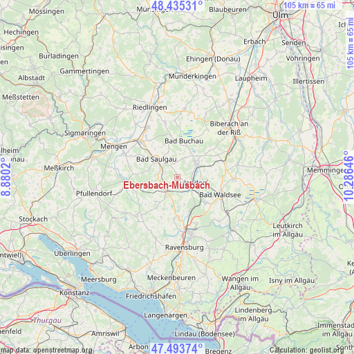
Ebersbach-Musbach GPS coordinates[2]
47° 58' 0.012" North, 9° 34' 59.988" East
| Map corner | latitude | longitude |
|---|---|---|
| Upper-left | 48.43531°, | 8.8802° |
| Center: | 47.96667°, | 9.58333° |
| Lower-right: | 47.49374°, | 10.28646° |
| Map W x H: | 104.7×104.7 km | = 65.1×65.1mi |
| max Lat: | 55.01917° ⇑95.9% North |
| Ebersbach-Musbach: | 47.96667° |
| min Lat: | ⇓4.1% South 47.40724° |
| min Long | Ebersbach-Musba | max Long |
| 5.92978° | 9.58333° | 14.98853° |
| W 43.5%⇐ | ⇒56.5% E |
Elevation
Elevation of Ebersbach-Musbach is 599 m = 1965 ft, and this is 349.9 m = 1148 ft above average elevation for this country.
| Max E: |
1256 m = 4121 ft | 5% |
| Ebersbach-Musbach | 599 m 1965 ft | |
| Avg. | 249.1 m = 817 ft | |
Min E: |
-5 m = -16 ft | 95% |
See also: Germany elevation on elevation.city.
Geographical zone
Ebersbach-Musbach is located in North temperate zone (between Tropic of Cancer and the Arctic Circle). Distance of this North polar circle is 2067.8 km =1284.9 mi to North.| Distance of | km | miles | from Ebersbach-Musbach |
|---|---|---|---|
| North Pole | 4673.7 | 2904.1 | to North |
| Arctic Circle | 2067.8 | 1284.9 | to North |
| Tropic Cancer | 2727.5 | 1694.8 | to South |
| Equator | 5333.4 | 3314 | to South |


Nearby cities:
15 places around Ebersbach-Musbach: (largest is in red/bold)
• Allmannsweiler
6.9 km =4.3 mi,  6°
6°
• Altshausen
5.3 km =3.3 mi,  225°
225°
• Aulendorf
4.4 km =2.7 mi,  113°
113°
• Bad Buchau
10.9 km =6.8 mi, 11°
• Bad Schussenried
6.9 km =4.3 mi,  52°
52°
• Boms
5.1 km =3.2 mi,  282°
282°
• Dürnau
10.6 km =6.6 mi,  348°
348°
• Ebenweiler
8.9 km =5.5 mi,  213°
213°
• Eichstegen
7.2 km =4.5 mi,  239°
239°
• Fleischwangen
11.9 km =7.4 mi,  218°
218°
• Fronreute
10.7 km =6.6 mi,  185°
185°
• Hoßkirch
10.1 km =6.3 mi,  259°
259°
• Saulgau
8.3 km =5.2 mi,  312°
312°
• Unterwaldhausen
11.4 km =7.1 mi, 229°
• Wolpertswende
8.3 km =5.2 mi,  165°
165°
Sources, notices
• [Note1] Compared only with cities in Germany existing in our database
• [Src1] Map data: © OpenStreetMap contributors (CC-BY-SA)
• [Src2] Other city data from geonames.org with taken over terms of usage.
• [Src3] Geographical zone / Annual Mean Temperature by Robert A. Rohde @ Wikipedia
