Bad Freienwalde geodata
Bad Freienwalde (Brandenburg) is a populated place; located in Germany in Europe/Berlin (GMT+2) time zone. With population of 13,075 people, there are 1231 cities with bigger population in this country. Compared to other cities in Germany, 80.3% of cities are located further ↓South; 98.1% of cities are located further ←West and 92.7% of cities have higher elevation than Bad Freienwalde. Note1
Administrative division(s):
- Level 1: Brandenburg
- Level 3: Landkreis Märkisch-Oderland
- Level 4: Bad Freienwalde (Oder)


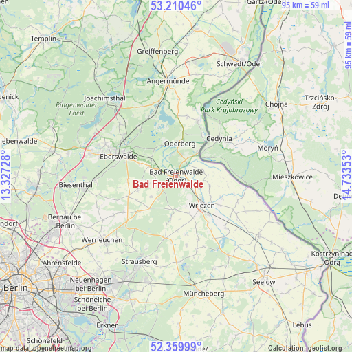
Bad Freienwalde GPS coordinates[2]
52° 47' 14.28" North, 14° 1' 49.44" East
| Map corner | latitude | longitude |
|---|---|---|
| Upper-left | 53.21046°, | 13.32728° |
| Center: | 52.7873°, | 14.0304° |
| Lower-right: | 52.35999°, | 14.73353° |
| Map W x H: | 94.6×94.6 km | = 58.8×58.8mi |
| max Lat: | 55.01917° ⇑19.7% North |
| Bad Freienwalde: | 52.7873° |
| min Lat: | ⇓80.3% South 47.40724° |
| min Long | Bad Freienwalde | max Long |
| 5.92978° | 14.0304° | 14.98853° |
| W 98.1%⇐ | ⇒1.9% E |
Elevation
Elevation of Bad Freienwalde is 14 m = 46 ft, and this is 235.1 m = 771 ft below average elevation for this country.
| Max E: |
1256 m = 4121 ft | 92.7% |
| Avg. | 249.1 m = 817 ft | |
| Bad Freienwalde | 14 m = 46 ft | |
Min E: |
-5 m = -16 ft | 7.3% |
See also: Germany elevation on elevation.city.
Geographical zone
Bad Freienwalde is located in North temperate zone (between Tropic of Cancer and the Arctic Circle). Distance of this North polar circle is 1531.8 km =951.8 mi to North.| Distance of | km | miles | from Bad Freienwalde |
|---|---|---|---|
| North Pole | 4137.7 | 2571 | to North |
| Arctic Circle | 1531.8 | 951.8 | to North |
| Tropic Cancer | 3263.5 | 2027.8 | to South |
| Equator | 5869.4 | 3647.1 | to South |


Nearby cities:
15 places around Bad Freienwalde: (largest is in red/bold)
• Bliesdorf
13.6 km =8.5 mi,  140°
140°
• Britz
18.4 km =11.4 mi,  307°
307°
• Chorin
16.6 km =10.3 mi,  320°
320°
• Eberswalde
15.1 km =9.4 mi,  290°
290°
• Falkenberg
5.3 km =3.3 mi, 292°
• Golzow
20.2 km =12.6 mi, 312°
• Hohenfinow
7.7 km =4.8 mi, 292°
• Hohensaaten
12.2 km =7.6 mi,  37°
37°
• Liepe
9.3 km =5.8 mi,  333°
333°
• Neulewin
18.1 km =11.2 mi,  112°
112°
• Neutrebbin
19 km =11.8 mi, 135°
• Niederfinow
8.6 km =5.3 mi, 306°
• Oderberg
8.8 km =5.5 mi,  6°
6°
• Prötzel
16.9 km =10.5 mi,  189°
189°
• Wriezen
10.2 km =6.3 mi, 136°
Sources, notices
• [Note1] Compared only with cities in Germany existing in our database
• [Src1] Map data: © OpenStreetMap contributors (CC-BY-SA)
• [Src2] Other city data from geonames.org with taken over terms of usage.
• [Src3] Geographical zone / Annual Mean Temperature by Robert A. Rohde @ Wikipedia
