Hohensaaten geodata
Hohensaaten (Brandenburg) is a populated place; located in Germany in Europe/Berlin (GMT+2) time zone. With population of 780 people, there are 7984 cities with bigger population in this country. Compared to other cities in Germany, 80.9% of cities are located further ↓South; 98.4% of cities are located further ←West and 96.6% of cities have higher elevation than Hohensaaten. Note1
Administrative division(s):
- Level 1: Brandenburg
- Level 3: Landkreis Märkisch-Oderland
- Level 4: Bad Freienwalde (Oder)


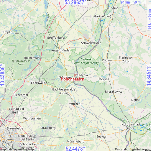
Hohensaaten GPS coordinates[2]
52° 52' 27.336" North, 14° 8' 31.128" East
| Map corner | latitude | longitude |
|---|---|---|
| Upper-left | 53.29657°, | 13.43886° |
| Center: | 52.87426°, | 14.14198° |
| Lower-right: | 52.4478°, | 14.84511° |
| Map W x H: | 94.4×94.4 km | = 58.7×58.7mi |
| max Lat: | 55.01917° ⇑19.1% North |
| Hohensaaten: | 52.87426° |
| min Lat: | ⇓80.9% South 47.40724° |
| min Long | Hohensaaten | max Long |
| 5.92978° | 14.14198° | 14.98853° |
| W 98.4%⇐ | ⇒1.6% E |
Elevation
Elevation of Hohensaaten is 5 m = 16 ft, and this is 244.1 m = 801 ft below average elevation for this country.
| Max E: |
1256 m = 4121 ft | 96.6% |
| Avg. | 249.1 m = 817 ft | |
| Hohensaaten | 5 m = 16 ft | |
Min E: |
-5 m = -16 ft | 3.4% |
See also: Germany elevation on elevation.city.
Geographical zone
Hohensaaten is located in North temperate zone (between Tropic of Cancer and the Arctic Circle). Distance of this North polar circle is 1522.1 km =945.8 mi to North.| Distance of | km | miles | from Hohensaaten |
|---|---|---|---|
| North Pole | 4128 | 2565 | to North |
| Arctic Circle | 1522.1 | 945.8 | to North |
| Tropic Cancer | 3273.1 | 2033.8 | to South |
| Equator | 5879.1 | 3653.1 | to South |


Nearby cities:
15 places around Hohensaaten: (largest is in red/bold)
• Angermünde
18.3 km =11.4 mi,  328°
328°
• Bad Freienwalde
12.2 km =7.6 mi,  217°
217°
• Bliesdorf
20.2 km =12.6 mi,  176°
176°
• Chorin
18.4 km =11.4 mi,  279°
279°
• Eberswalde
22.1 km =13.7 mi,  258°
258°
• Falkenberg
14.6 km =9.1 mi,  238°
238°
• Hohenfinow
16.1 km =10 mi,  245°
245°
• Liepe
11.7 km =7.3 mi, 263°
• Meyenburg
20 km =12.4 mi,  18°
18°
• Neulewin
19.1 km =11.9 mi,  151°
151°
• Niederfinow
15 km =9.3 mi, 252°
• Oderberg
6.6 km =4.1 mi, 261°
• Pinnow
21.2 km =13.2 mi,  349°
349°
• Schöneberg
14.9 km =9.3 mi,  0°
0°
• Wriezen
17.1 km =10.6 mi, 181°
Sources, notices
• [Note1] Compared only with cities in Germany existing in our database
• [Src1] Map data: © OpenStreetMap contributors (CC-BY-SA)
• [Src2] Other city data from geonames.org with taken over terms of usage.
• [Src3] Geographical zone / Annual Mean Temperature by Robert A. Rohde @ Wikipedia
