Nieder-Hilbersheim geodata
Nieder-Hilbersheim (Rheinland-Pfalz) is a seat of a fourth-order administrative division; located in Germany in Europe/Berlin (GMT+2) time zone. With population of 627 people, there are 8671 cities with bigger population in this country. Compared to other cities in Germany, 66.1% of cities are located further ↑North; 76.4% of cities are located further →East and 52.2% of cities have higher elevation than Nieder-Hilbersheim. Note1
Administrative division(s):
- Level 1: Rheinland-Pfalz
- Level 3: Landkreis Mainz-Bingen
- Level 4: Nieder-Hilbersheim


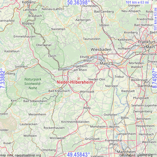
Nieder-Hilbersheim GPS coordinates[2]
49° 54' 47.988" North, 8° 2' 30.984" East
| Map corner | latitude | longitude |
|---|---|---|
| Upper-left | 50.36398°, | 7.33882° |
| Center: | 49.91333°, | 8.04194° |
| Lower-right: | 49.45843°, | 8.74507° |
| Map W x H: | 100.7×100.7 km | = 62.6×62.6mi |
| max Lat: | 55.01917° ⇑66.1% North |
| Nieder-Hilbersheim: | 49.91333° |
| min Lat: | ⇓33.9% South 47.40724° |
| min Long | Nieder-Hilbersh | max Long |
| 5.92978° | 8.04194° | 14.98853° |
| W 23.6%⇐ | ⇒76.4% E |
Elevation
Elevation of Nieder-Hilbersheim is 210 m = 689 ft, and this is 39.1 m = 128 ft below average elevation for this country.
| Max E: |
1256 m = 4121 ft | 52.2% |
| Avg. | 249.1 m = 817 ft | |
| Nieder-Hilbersheim | 210 m = 689 ft | |
Min E: |
-5 m = -16 ft | 47.8% |
See also: Germany elevation on elevation.city.
Geographical zone
Nieder-Hilbersheim is located in North temperate zone (between Tropic of Cancer and the Arctic Circle). Distance of this North polar circle is 1851.3 km =1150.3 mi to North.| Distance of | km | miles | from Nieder-Hilbersheim |
|---|---|---|---|
| North Pole | 4457.2 | 2769.6 | to North |
| Arctic Circle | 1851.3 | 1150.3 | to North |
| Tropic Cancer | 2943.9 | 1829.3 | to South |
| Equator | 5549.8 | 3448.5 | to South |


Nearby cities:
15 places around Nieder-Hilbersheim: (largest is in red/bold)
• Appenheim
2 km =1.2 mi,  341°
341°
• Aspisheim
4.5 km =2.8 mi,  250°
250°
• Bubenheim
2.9 km =1.8 mi,  71°
71°
• Engelstadt
2 km =1.2 mi,  121°
121°
• Gau-Algesheim
5.2 km =3.2 mi, 338°
• Horrweiler
5.6 km =3.5 mi, 254°
• Jugenheim
3.8 km =2.4 mi,  125°
125°
• Ober-Hilbersheim
1.8 km =1.1 mi,  212°
212°
• Ockenheim
6.1 km =3.8 mi,  303°
303°
• Partenheim
4.4 km =2.7 mi,  138°
138°
• Sankt Johann
5.5 km =3.4 mi,  201°
201°
• Schwabenheim
4.2 km =2.6 mi, 65°
• Stadecken-Elsheim
6 km =3.7 mi,  91°
91°
• Vendersheim
5.6 km =3.5 mi,  159°
159°
• Wolfsheim
4.6 km =2.9 mi,  182°
182°
Sources, notices
• [Note1] Compared only with cities in Germany existing in our database
• [Src1] Map data: © OpenStreetMap contributors (CC-BY-SA)
• [Src2] Other city data from geonames.org with taken over terms of usage.
• [Src3] Geographical zone / Annual Mean Temperature by Robert A. Rohde @ Wikipedia
