Alfstedt geodata
Alfstedt (Lower Saxony) is a seat of a fourth-order administrative division; located in Germany in Europe/Berlin (GMT+2) time zone. With population of 879 people, there are 7594 cities with bigger population in this country. Compared to other cities in Germany, 86.2% of cities are located further ↓South; 64.5% of cities are located further →East and 92% of cities have higher elevation than Alfstedt. Note1


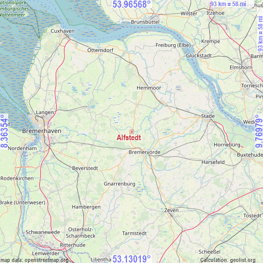
Alfstedt GPS coordinates[2]
53° 33' 0" North, 9° 4' 0.012" East
| Map corner | latitude | longitude |
|---|---|---|
| Upper-left | 53.96568°, | 8.36354° |
| Center: | 53.55°, | 9.06667° |
| Lower-right: | 53.13019°, | 9.76979° |
| Map W x H: | 92.9×92.9 km | = 57.7×57.7mi |
| max Lat: | 55.01917° ⇑13.8% North |
| Alfstedt: | 53.55° |
| min Lat: | ⇓86.2% South 47.40724° |
| min Long | Alfstedt | max Long |
| 5.92978° | 9.06667° | 14.98853° |
| W 35.5%⇐ | ⇒64.5% E |
Elevation
Elevation of Alfstedt is 16 m = 52 ft, and this is 233.1 m = 765 ft below average elevation for this country.
| Max E: |
1256 m = 4121 ft | 92% |
| Avg. | 249.1 m = 817 ft | |
| Alfstedt | 16 m = 52 ft | |
Min E: |
-5 m = -16 ft | 8% |
See also: Germany elevation on elevation.city.
Geographical zone
Alfstedt is located in North temperate zone (between Tropic of Cancer and the Arctic Circle). Distance of this North polar circle is 1447 km =899.1 mi to North.| Distance of | km | miles | from Alfstedt |
|---|---|---|---|
| North Pole | 4052.9 | 2518.4 | to North |
| Arctic Circle | 1447 | 899.1 | to North |
| Tropic Cancer | 3348.3 | 2080.5 | to South |
| Equator | 5954.2 | 3699.8 | to South |


Nearby cities:
15 places around Alfstedt: (largest is in red/bold)
• Armstorf
5.6 km =3.5 mi,  0°
0°
• Barchel
9.5 km =5.9 mi,  193°
193°
• Basdahl
12.5 km =7.8 mi,  200°
200°
• Bei der Höhne
5 km =3.1 mi,  143°
143°
• Bremervörde
8.9 km =5.5 mi,  145°
145°
• Ebersdorf
3 km =1.9 mi, 202°
• Estorf
9.4 km =5.8 mi,  72°
72°
• Hipstedt
9.9 km =6.2 mi,  221°
221°
• Hollnseth
4.3 km =2.7 mi,  30°
30°
• Kranenburg
11.1 km =6.9 mi,  55°
55°
• Köhlen
12.7 km =7.9 mi,  265°
265°
• Lamstedt
9.5 km =5.9 mi,  13°
13°
• Mittelstenahe
11.3 km =7 mi,  348°
348°
• Oerel
7.5 km =4.7 mi, 188°
• Oldendorf
12.7 km =7.9 mi, 72°
Sources, notices
• [Note1] Compared only with cities in Germany existing in our database
• [Src1] Map data: © OpenStreetMap contributors (CC-BY-SA)
• [Src2] Other city data from geonames.org with taken over terms of usage.
• [Src3] Geographical zone / Annual Mean Temperature by Robert A. Rohde @ Wikipedia
