Bei der Höhne geodata
Bei der Höhne (Lower Saxony) is a populated place; located in Germany in Europe/Berlin (GMT+2) time zone. With population of 1,823 people, there are 5308 cities with bigger population in this country. Compared to other cities in Germany, 85.7% of cities are located further ↓South; 63.8% of cities are located further →East and 96.2% of cities have higher elevation than Bei der Höhne. Note1


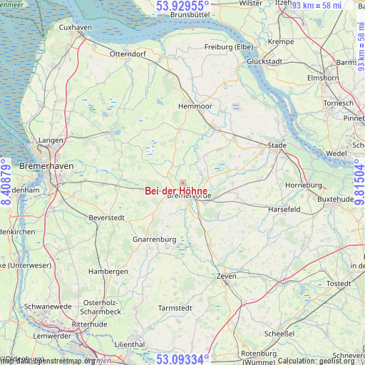
Bei der Höhne GPS coordinates[2]
53° 30' 48.636" North, 9° 6' 42.876" East
| Map corner | latitude | longitude |
|---|---|---|
| Upper-left | 53.92955°, | 8.40879° |
| Center: | 53.51351°, | 9.11191° |
| Lower-right: | 53.09334°, | 9.81504° |
| Map W x H: | 93×93 km | = 57.8×57.8mi |
| max Lat: | 55.01917° ⇑14.3% North |
| Bei der Höhne: | 53.51351° |
| min Lat: | ⇓85.7% South 47.40724° |
| min Long | Bei der Höhne | max Long |
| 5.92978° | 9.11191° | 14.98853° |
| W 36.2%⇐ | ⇒63.8% E |
Elevation
Elevation of Bei der Höhne is 6 m = 20 ft, and this is 243.1 m = 798 ft below average elevation for this country.
| Max E: |
1256 m = 4121 ft | 96.2% |
| Avg. | 249.1 m = 817 ft | |
| Bei der Höhne | 6 m = 20 ft | |
Min E: |
-5 m = -16 ft | 3.8% |
See also: Germany elevation on elevation.city.
Geographical zone
Bei der Höhne is located in North temperate zone (between Tropic of Cancer and the Arctic Circle). Distance of this North polar circle is 1451 km =901.6 mi to North.| Distance of | km | miles | from Bei der Höhne |
|---|---|---|---|
| North Pole | 4056.9 | 2520.8 | to North |
| Arctic Circle | 1451 | 901.6 | to North |
| Tropic Cancer | 3344.2 | 2078 | to South |
| Equator | 5950.1 | 3697.2 | to South |


Nearby cities:
15 places around Bei der Höhne: (largest is in red/bold)
• Alfstedt
5 km =3.1 mi,  323°
323°
• Armstorf
10.1 km =6.3 mi,  342°
342°
• Barchel
7.3 km =4.5 mi,  224°
224°
• Basdahl
10.6 km =6.6 mi, 224°
• Bremervörde
3.8 km =2.4 mi,  147°
147°
• Deinstedt
13.4 km =8.3 mi,  143°
143°
• Ebersdorf
4.4 km =2.7 mi,  287°
287°
• Estorf
9.2 km =5.7 mi,  40°
40°
• Hipstedt
10.2 km =6.3 mi,  250°
250°
• Hollnseth
7.8 km =4.8 mi,  354°
354°
• Kranenburg
12.1 km =7.5 mi,  31°
31°
• Lamstedt
13.3 km =8.3 mi,  356°
356°
• Oerel
5.3 km =3.3 mi,  230°
230°
• Oldendorf
12 km =7.5 mi,  49°
49°
• Sandbostel
11.6 km =7.2 mi,  174°
174°
Sources, notices
• [Note1] Compared only with cities in Germany existing in our database
• [Src1] Map data: © OpenStreetMap contributors (CC-BY-SA)
• [Src2] Other city data from geonames.org with taken over terms of usage.
• [Src3] Geographical zone / Annual Mean Temperature by Robert A. Rohde @ Wikipedia
