Bremervörde geodata
Bremervörde (Lower Saxony) is a populated place; located in Germany in Europe/Berlin (GMT+2) time zone. With population of 19,268 people, there are 809 cities with bigger population in this country. Compared to other cities in Germany, 85.4% of cities are located further ↓South; 63.3% of cities are located further →East and 95.2% of cities have higher elevation than Bremervörde. Note1


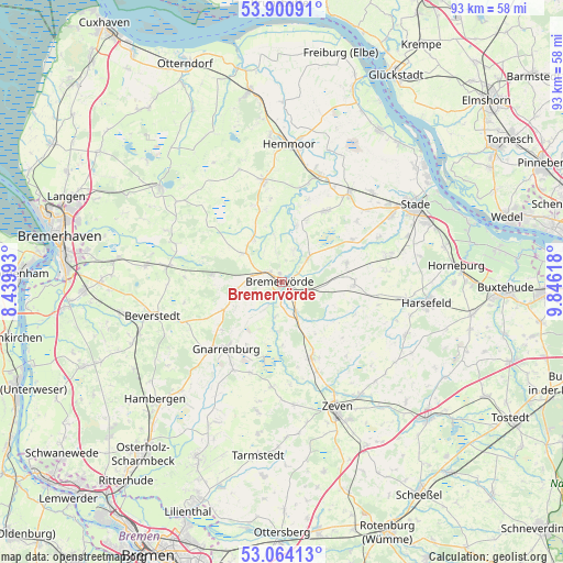
Bremervörde GPS coordinates[2]
53° 29' 4.488" North, 9° 8' 35.016" East
| Map corner | latitude | longitude |
|---|---|---|
| Upper-left | 53.90091°, | 8.43993° |
| Center: | 53.48458°, | 9.14306° |
| Lower-right: | 53.06413°, | 9.84618° |
| Map W x H: | 93×93 km | = 57.8×57.8mi |
| max Lat: | 55.01917° ⇑14.6% North |
| Bremervörde: | 53.48458° |
| min Lat: | ⇓85.4% South 47.40724° |
| min Long | Bremervörde | max Long |
| 5.92978° | 9.14306° | 14.98853° |
| W 36.7%⇐ | ⇒63.3% E |
Elevation
Elevation of Bremervörde is 8 m = 26 ft, and this is 241.1 m = 791 ft below average elevation for this country.
| Max E: |
1256 m = 4121 ft | 95.2% |
| Avg. | 249.1 m = 817 ft | |
| Bremervörde | 8 m = 26 ft | |
Min E: |
-5 m = -16 ft | 4.8% |
See also: Germany elevation on elevation.city.
Geographical zone
Bremervörde is located in North temperate zone (between Tropic of Cancer and the Arctic Circle). Distance of this North polar circle is 1454.2 km =903.6 mi to North.| Distance of | km | miles | from Bremervörde |
|---|---|---|---|
| North Pole | 4060.1 | 2522.8 | to North |
| Arctic Circle | 1454.2 | 903.6 | to North |
| Tropic Cancer | 3341 | 2076 | to South |
| Equator | 5946.9 | 3695.2 | to South |


Nearby cities:
15 places around Bremervörde: (largest is in red/bold)
• Alfstedt
8.9 km =5.5 mi,  325°
325°
• Barchel
7.5 km =4.7 mi,  254°
254°
• Basdahl
10.4 km =6.5 mi, 245°
• Bei der Höhne
3.8 km =2.4 mi, 327°
• Deinstedt
9.6 km =6 mi,  141°
141°
• Ebersdorf
7.7 km =4.8 mi,  305°
305°
• Estorf
10.9 km =6.8 mi,  21°
21°
• Farven
12.8 km =8 mi,  116°
116°
• Hipstedt
11.7 km =7.3 mi,  269°
269°
• Hollnseth
11.3 km =7 mi,  345°
345°
• Kutenholz
11.8 km =7.3 mi,  91°
91°
• Oerel
6.2 km =3.9 mi, 268°
• Oldendorf
13.1 km =8.1 mi,  32°
32°
• Sandbostel
8.4 km =5.2 mi,  186°
186°
• Selsingen
13.2 km =8.2 mi,  159°
159°
Sources, notices
• [Note1] Compared only with cities in Germany existing in our database
• [Src1] Map data: © OpenStreetMap contributors (CC-BY-SA)
• [Src2] Other city data from geonames.org with taken over terms of usage.
• [Src3] Geographical zone / Annual Mean Temperature by Robert A. Rohde @ Wikipedia
