Landensberg geodata
Landensberg (Bavaria) is a seat of a fourth-order administrative division; located in Germany in Europe/Berlin (GMT+2) time zone. With population of 726 people, there are 8212 cities with bigger population in this country. Compared to other cities in Germany, 89.8% of cities are located further ↑North; 59.4% of cities are located further ←West and 89.9% of cities have lower elevation than Landensberg. Note1
Administrative division(s):
- Level 1: Bavaria
- Level 2: Swabia
- Level 3: Landkreis Günzburg
- Level 4: Landensberg


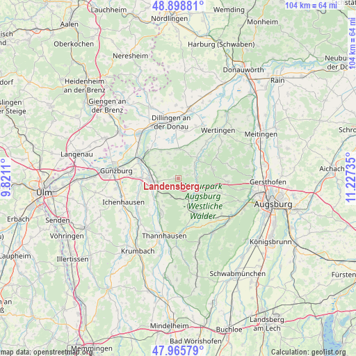
Landensberg GPS coordinates[2]
48° 26' 3.984" North, 10° 31' 27.192" East
| Map corner | latitude | longitude |
|---|---|---|
| Upper-left | 48.89881°, | 9.8211° |
| Center: | 48.43444°, | 10.52422° |
| Lower-right: | 47.96579°, | 11.22735° |
| Map W x H: | 103.7×103.7 km | = 64.4×64.4mi |
| max Lat: | 55.01917° ⇑89.8% North |
| Landensberg: | 48.43444° |
| min Lat: | ⇓10.2% South 47.40724° |
| min Long | Landensberg | max Long |
| 5.92978° | 10.52422° | 14.98853° |
| W 59.4%⇐ | ⇒40.6% E |
Elevation
Elevation of Landensberg is 513 m = 1683 ft, and this is 263.9 m = 866 ft above average elevation for this country.
| Max E: |
1256 m = 4121 ft | 10.1% |
| Landensberg | 513 m 1683 ft | |
| Avg. | 249.1 m = 817 ft | |
Min E: |
-5 m = -16 ft | 89.9% |
See also: Germany elevation on elevation.city.
Geographical zone
Landensberg is located in North temperate zone (between Tropic of Cancer and the Arctic Circle). Distance of this North polar circle is 2015.8 km =1252.6 mi to North.| Distance of | km | miles | from Landensberg |
|---|---|---|---|
| North Pole | 4621.7 | 2871.8 | to North |
| Arctic Circle | 2015.8 | 1252.6 | to North |
| Tropic Cancer | 2779.5 | 1727.1 | to South |
| Equator | 5385.4 | 3346.3 | to South |


Nearby cities:
15 places around Landensberg: (largest is in red/bold)
• Aislingen
9.4 km =5.8 mi,  328°
328°
• Altenmünster
6 km =3.7 mi,  55°
55°
• Burgau
8.4 km =5.2 mi,  267°
267°
• Dinkelscherben
10.7 km =6.6 mi,  153°
153°
• Dürrlauingen
7.9 km =4.9 mi,  296°
296°
• Glött
7.9 km =4.9 mi,  337°
337°
• Haldenwang
5.6 km =3.5 mi, 273°
• Holzheim
8.9 km =5.5 mi,  3°
3°
• Jettingen-Scheppach
8.1 km =5 mi,  231°
231°
• Roßhaupten
4.1 km =2.5 mi,  262°
262°
• Röfingen
6.1 km =3.8 mi, 259°
• Villenbach
10.6 km =6.6 mi,  38°
38°
• Welden
10.3 km =6.4 mi,  77°
77°
• Winterbach
4.7 km =2.9 mi,  319°
319°
• Zusmarshausen
6.7 km =4.2 mi,  124°
124°
Sources, notices
• [Note1] Compared only with cities in Germany existing in our database
• [Src1] Map data: © OpenStreetMap contributors (CC-BY-SA)
• [Src2] Other city data from geonames.org with taken over terms of usage.
• [Src3] Geographical zone / Annual Mean Temperature by Robert A. Rohde @ Wikipedia
