Haseldorf geodata
Haseldorf (Schleswig-Holstein) is a seat of a fourth-order administrative division; located in Germany in Europe/Berlin (GMT+2) time zone. With population of 1,743 people, there are 5434 cities with bigger population in this country. Compared to other cities in Germany, 87.6% of cities are located further ↓South; 56.3% of cities are located further →East and 98.6% of cities have higher elevation than Haseldorf. Note1


Haseldorf GPS coordinates[2]
53° 38' 16.08" North, 9° 35' 29.436" East
| Map corner | latitude | longitude |
|---|---|---|
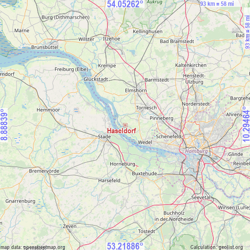
| Upper-left | 54.05262°, | 8.88839° |
| Center: | 53.6378°, | 9.59151° |
| Lower-right: | 53.21886°, | 10.29464° |
| Map W x H: | 92.7×92.7 km | = 57.6×57.6mi |
| max Lat: | 55.01917° ⇑12.4% North |
| Haseldorf: | 53.6378° |
| min Lat: | ⇓87.6% South 47.40724° |
| min Long | Haseldorf | max Long |
| 5.92978° | 9.59151° | 14.98853° |
| W 43.7%⇐ | ⇒56.3% E |
Elevation
Elevation of Haseldorf is 1 m = 3 ft, and this is 248.1 m = 814 ft below average elevation for this country.
| Max E: |
1256 m = 4121 ft | 98.6% |
| Avg. | 249.1 m = 817 ft | |
| Haseldorf | 1 m = 3 ft | |
Min E: |
-5 m = -16 ft | 1.4% |
See also: Germany elevation on elevation.city.
Geographical zone
Haseldorf is located in North temperate zone (between Tropic of Cancer and the Arctic Circle). Distance of this North polar circle is 1437.2 km =893 mi to North.| Distance of | km | miles | from Haseldorf |
|---|---|---|---|
| North Pole | 4043.1 | 2512.3 | to North |
| Arctic Circle | 1437.2 | 893 | to North |
| Tropic Cancer | 3358 | 2086.6 | to South |
| Equator | 5964 | 3705.9 | to South |


Nearby cities:
15 places around Haseldorf: (largest is in red/bold)
• Agathenburg
9.4 km =5.8 mi,  204°
204°
• Groß Nordende
7.9 km =4.9 mi,  29°
29°
• Grünendeich
7.7 km =4.8 mi,  169°
169°
• Haselau
3.3 km =2.1 mi,  35°
35°
• Heist
4.1 km =2.5 mi,  70°
70°
• Hetlingen
4.6 km =2.9 mi,  138°
138°
• Holm
5.5 km =3.4 mi,  115°
115°
• Moorrege
5.9 km =3.7 mi,  57°
57°
• Neuendeich
5.3 km =3.3 mi,  18°
18°
• Seester
8.9 km =5.5 mi,  2°
2°
• Seestermühe
7.1 km =4.4 mi,  346°
346°
• Stade
9.1 km =5.7 mi,  236°
236°
• Steinkirchen
8.1 km =5 mi, 170°
• Uetersen
7.3 km =4.5 mi, 40°
• Wedel
9.3 km =5.8 mi,  130°
130°
Sources, notices
• [Note1] Compared only with cities in Germany existing in our database
• [Src1] Map data: © OpenStreetMap contributors (CC-BY-SA)
• [Src2] Other city data from geonames.org with taken over terms of usage.
• [Src3] Geographical zone / Annual Mean Temperature by Robert A. Rohde @ Wikipedia
