Langsur geodata
Langsur (Rheinland-Pfalz) is a seat of a fourth-order administrative division; located in Germany in Europe/Berlin (GMT+2) time zone. With population of 1,634 people, there are 5631 cities with bigger population in this country. Compared to other cities in Germany, 70.7% of cities are located further ↑North; 97.8% of cities are located further →East and 61.3% of cities have higher elevation than Langsur. Note1
Administrative division(s):
- Level 1: Rheinland-Pfalz
- Level 3: Landkreis Trier-Saarburg
- Level 4: Langsur


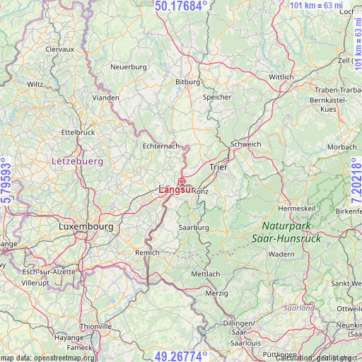
Langsur GPS coordinates[2]
49° 43' 27.912" North, 6° 29' 56.616" East
| Map corner | latitude | longitude |
|---|---|---|
| Upper-left | 50.17684°, | 5.79593° |
| Center: | 49.72442°, | 6.49906° |
| Lower-right: | 49.26774°, | 7.20218° |
| Map W x H: | 101.1×101.1 km | = 62.8×62.8mi |
| max Lat: | 55.01917° ⇑70.7% North |
| Langsur: | 49.72442° |
| min Lat: | ⇓29.3% South 47.40724° |
| min Long | Langsur | max Long |
| 5.92978° | 6.49906° | 14.98853° |
| W 2.2%⇐ | ⇒97.8% E |
Elevation
Elevation of Langsur is 143 m = 469 ft, and this is 106.1 m = 348 ft below average elevation for this country.
| Max E: |
1256 m = 4121 ft | 61.3% |
| Avg. | 249.1 m = 817 ft | |
| Langsur | 143 m = 469 ft | |
Min E: |
-5 m = -16 ft | 38.7% |
See also: Germany elevation on elevation.city.
Geographical zone
Langsur is located in North temperate zone (between Tropic of Cancer and the Arctic Circle). Distance of this North polar circle is 1872.3 km =1163.4 mi to North.| Distance of | km | miles | from Langsur |
|---|---|---|---|
| North Pole | 4478.2 | 2782.6 | to North |
| Arctic Circle | 1872.3 | 1163.4 | to North |
| Tropic Cancer | 2922.9 | 1816.2 | to South |
| Equator | 5528.8 | 3435.4 | to South |


Nearby cities:
15 places around Langsur: (largest is in red/bold)
• Aach
9.8 km =6.1 mi,  47°
47°
• Igel
4.3 km =2.7 mi,  111°
111°
• Kanzem
8.6 km =5.3 mi,  138°
138°
• Konz
6.2 km =3.9 mi,  115°
115°
• Mannebach
10.2 km =6.3 mi,  172°
172°
• Nittel
9 km =5.6 mi,  203°
203°
• Oberbillig
1.8 km =1.1 mi,  161°
161°
• Onsdorf
8.4 km =5.2 mi,  187°
187°
• Tawern
6.5 km =4 mi, 168°
• Temmels
4.6 km =2.9 mi,  211°
211°
• Trierweiler
6.1 km =3.8 mi, 46°
• Wasserliesch
3.5 km =2.2 mi, 123°
• Wawern
9 km =5.6 mi, 156°
• Wellen
8 km =5 mi,  216°
216°
• Wiltingen
9.9 km =6.2 mi, 137°
Sources, notices
• [Note1] Compared only with cities in Germany existing in our database
• [Src1] Map data: © OpenStreetMap contributors (CC-BY-SA)
• [Src2] Other city data from geonames.org with taken over terms of usage.
• [Src3] Geographical zone / Annual Mean Temperature by Robert A. Rohde @ Wikipedia
