Ühlingen-Birkendorf geodata
Ühlingen-Birkendorf (Baden-Württemberg) is a seat of a fourth-order administrative division; located in Germany in Europe/Berlin (GMT+2) time zone. With population of 5,269 people, there are 2711 cities with bigger population in this country. Compared to other cities in Germany, 98.6% of cities are located further ↑North; 72.8% of cities are located further →East and 96.3% of cities have lower elevation than Ühlingen-Birkendorf. Note1
Administrative division(s):
- Level 1: Baden-Württemberg
- Level 2: Freiburg Region
- Level 3: Landkreis Waldshut
- Level 4: Ühlingen-Birkendorf


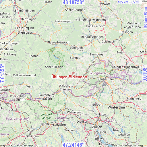
Ühlingen-Birkendorf GPS coordinates[2]
47° 43' 0.012" North, 8° 19' 0.012" East
| Map corner | latitude | longitude |
|---|---|---|
| Upper-left | 48.18758°, | 7.61355° |
| Center: | 47.71667°, | 8.31667° |
| Lower-right: | 47.24146°, | 9.0198° |
| Map W x H: | 105.2×105.2 km | = 65.4×65.4mi |
| max Lat: | 55.01917° ⇑98.6% North |
| Ühlingen-Birkendorf: | 47.71667° |
| min Lat: | ⇓1.4% South 47.40724° |
| min Long | Ühlingen-Birke | max Long |
| 5.92978° | 8.31667° | 14.98853° |
| W 27.2%⇐ | ⇒72.8% E |
Elevation
Elevation of Ühlingen-Birkendorf is 637 m = 2090 ft, and this is 387.9 m = 1273 ft above average elevation for this country.
| Max E: |
1256 m = 4121 ft | 3.7% |
| Ühlingen-Birkendorf | 637 m 2090 ft | |
| Avg. | 249.1 m = 817 ft | |
Min E: |
-5 m = -16 ft | 96.3% |
See also: Germany elevation on elevation.city.
Geographical zone
Ühlingen-Birkendorf is located in North temperate zone (between Tropic of Cancer and the Arctic Circle). Distance of this North polar circle is 2095.6 km =1302.1 mi to North.| Distance of | km | miles | from Ühlingen-Birkendorf |
|---|---|---|---|
| North Pole | 4701.5 | 2921.4 | to North |
| Arctic Circle | 2095.6 | 1302.1 | to North |
| Tropic Cancer | 2699.7 | 1677.5 | to South |
| Equator | 5305.6 | 3296.7 | to South |


Nearby cities:
15 places around Ühlingen-Birkendorf: (largest is in red/bold)
• Bonndorf
11.5 km =7.1 mi,  9°
9°
• Dachsberg
16.3 km =10.1 mi,  275°
275°
• Dettighofen
16.3 km =10.1 mi,  129°
129°
• Eggingen
6.5 km =4 mi,  106°
106°
• Grafenhausen
7.9 km =4.9 mi,  325°
325°
• Häusern
11.8 km =7.3 mi,  288°
288°
• Höchenschwand
11.4 km =7.1 mi, 279°
• Lauchringen
10 km =6.2 mi,  180°
180°
• Sankt Blasien
15.1 km =9.4 mi, 289°
• Schluchsee
14.9 km =9.3 mi,  318°
318°
• Staufen
9.1 km =5.7 mi,  299°
299°
• Stühlingen
10.4 km =6.5 mi,  71°
71°
• Waldshut-Tiengen
12.8 km =8 mi,  215°
215°
• Weilheim
8.4 km =5.2 mi,  228°
228°
• Wutöschingen
7.3 km =4.5 mi,  148°
148°
Sources, notices
• [Note1] Compared only with cities in Germany existing in our database
• [Src1] Map data: © OpenStreetMap contributors (CC-BY-SA)
• [Src2] Other city data from geonames.org with taken over terms of usage.
• [Src3] Geographical zone / Annual Mean Temperature by Robert A. Rohde @ Wikipedia
