Hainau geodata
Hainau (Rheinland-Pfalz) is a seat of a fourth-order administrative division; located in Germany in Europe/Berlin (GMT+2) time zone. With population of 189 people, there are 10522 cities with bigger population in this country. Compared to other cities in Germany, 58.5% of cities are located further ↑North; 81.4% of cities are located further →East and 58.1% of cities have lower elevation than Hainau. Note1


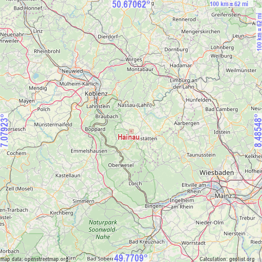
Hainau GPS coordinates[2]
50° 13' 22.368" North, 7° 46' 56.46" East
| Map corner | latitude | longitude |
|---|---|---|
| Upper-left | 50.67062°, | 7.07923° |
| Center: | 50.22288°, | 7.78235° |
| Lower-right: | 49.7709°, | 8.48548° |
| Map W x H: | 100×100 km | = 62.1×62.1mi |
| max Lat: | 55.01917° ⇑58.5% North |
| Hainau: | 50.22288° |
| min Lat: | ⇓41.5% South 47.40724° |
| min Long | Hainau | max Long |
| 5.92978° | 7.78235° | 14.98853° |
| W 18.6%⇐ | ⇒81.4% E |
Elevation
Elevation of Hainau is 279 m = 915 ft, and this is 29.9 m = 98 ft above average elevation for this country.
| Max E: |
1256 m = 4121 ft | 41.9% |
| Hainau | 279 m 915 ft | |
| Avg. | 249.1 m = 817 ft | |
Min E: |
-5 m = -16 ft | 58.1% |
See also: Germany elevation on elevation.city.
Geographical zone
Hainau is located in North temperate zone (between Tropic of Cancer and the Arctic Circle). Distance of this North polar circle is 1816.9 km =1129 mi to North.| Distance of | km | miles | from Hainau |
|---|---|---|---|
| North Pole | 4422.8 | 2748.2 | to North |
| Arctic Circle | 1816.9 | 1129 | to North |
| Tropic Cancer | 2978.3 | 1850.6 | to South |
| Equator | 5584.3 | 3469.9 | to South |


Nearby cities:
15 places around Hainau: (largest is in red/bold)
• Berg
4.1 km =2.5 mi,  30°
30°
• Bogel
3.9 km =2.4 mi,  161°
161°
• Dessighofen
4 km =2.5 mi,  349°
349°
• Ehr
1.7 km =1.1 mi,  5°
5°
• Endlichhofen
3.5 km =2.2 mi,  132°
132°
• Geisig
3.5 km =2.2 mi, 9°
• Gemmerich
1.8 km =1.1 mi,  288°
288°
• Himmighofen
1.7 km =1.1 mi,  224°
224°
• Kasdorf
1.8 km =1.1 mi,  175°
175°
• Marienfels
2.9 km =1.8 mi,  48°
48°
• Miehlen
3.5 km =2.2 mi,  84°
84°
• Niederbachheim
3.1 km =1.9 mi,  337°
337°
• Oberbachheim
3.6 km =2.2 mi,  316°
316°
• Ruppertshofen
3 km =1.9 mi,  146°
146°
• Winterwerb
3.4 km =2.1 mi,  295°
295°
Sources, notices
• [Note1] Compared only with cities in Germany existing in our database
• [Src1] Map data: © OpenStreetMap contributors (CC-BY-SA)
• [Src2] Other city data from geonames.org with taken over terms of usage.
• [Src3] Geographical zone / Annual Mean Temperature by Robert A. Rohde @ Wikipedia
