Ettringen geodata
Ettringen (Bavaria) is a seat of a fourth-order administrative division; located in Germany in Europe/Berlin (GMT+2) time zone. With population of 3,372 people, there are 3702 cities with bigger population in this country. Compared to other cities in Germany, 94.1% of cities are located further ↑North; 61.6% of cities are located further ←West and 94.3% of cities have lower elevation than Ettringen. Note1
Administrative division(s):
- Level 1: Bavaria
- Level 2: Swabia
- Level 3: Landkreis Unterallgäu
- Level 4: Ettringen


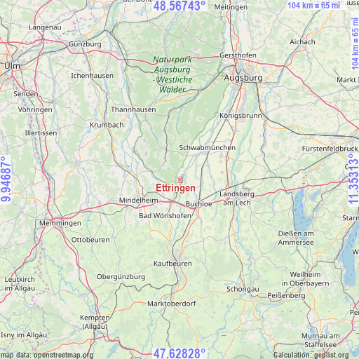
Ettringen GPS coordinates[2]
48° 6' 0" North, 10° 39' 0" East
| Map corner | latitude | longitude |
|---|---|---|
| Upper-left | 48.56743°, | 9.94687° |
| Center: | 48.1°, | 10.65° |
| Lower-right: | 47.62828°, | 11.35313° |
| Map W x H: | 104.4×104.4 km | = 64.9×64.9mi |
| max Lat: | 55.01917° ⇑94.1% North |
| Ettringen: | 48.1° |
| min Lat: | ⇓5.9% South 47.40724° |
| min Long | Ettringen | max Long |
| 5.92978° | 10.65° | 14.98853° |
| W 61.6%⇐ | ⇒38.4% E |
Elevation
Elevation of Ettringen is 583 m = 1913 ft, and this is 333.9 m = 1095 ft above average elevation for this country.
| Max E: |
1256 m = 4121 ft | 5.7% |
| Ettringen | 583 m 1913 ft | |
| Avg. | 249.1 m = 817 ft | |
Min E: |
-5 m = -16 ft | 94.3% |
See also: Germany elevation on elevation.city.
Geographical zone
Ettringen is located in North temperate zone (between Tropic of Cancer and the Arctic Circle). Distance of this North polar circle is 2053 km =1275.7 mi to North.| Distance of | km | miles | from Ettringen |
|---|---|---|---|
| North Pole | 4658.8 | 2894.8 | to North |
| Arctic Circle | 2053 | 1275.7 | to North |
| Tropic Cancer | 2742.3 | 1704 | to South |
| Equator | 5348.2 | 3323.2 | to South |


Nearby cities:
15 places around Ettringen: (largest is in red/bold)
• Amberg
4.5 km =2.8 mi,  146°
146°
• Bad Wörishofen
11.1 km =6.9 mi,  200°
200°
• Buchloe
9 km =5.6 mi,  141°
141°
• Eppishausen
12.4 km =7.7 mi,  306°
306°
• Hiltenfingen
8.4 km =5.2 mi,  36°
36°
• Hurlach
12.1 km =7.5 mi,  80°
80°
• Lamerdingen
6.7 km =4.2 mi,  97°
97°
• Langerringen
9.6 km =6 mi,  57°
57°
• Markt Wald
6.5 km =4 mi, 309°
• Mittelneufnach
9.3 km =5.8 mi,  335°
335°
• Scherstetten
9 km =5.6 mi,  355°
355°
• Schwabmünchen
11.9 km =7.4 mi, 41°
• Tussenhausen
6.6 km =4.1 mi,  272°
272°
• Türkheim
4.1 km =2.5 mi,  188°
188°
• Wiedergeltingen
7 km =4.3 mi,  165°
165°
Sources, notices
• [Note1] Compared only with cities in Germany existing in our database
• [Src1] Map data: © OpenStreetMap contributors (CC-BY-SA)
• [Src2] Other city data from geonames.org with taken over terms of usage.
• [Src3] Geographical zone / Annual Mean Temperature by Robert A. Rohde @ Wikipedia
