Türkheim geodata
Türkheim (Bavaria) is a populated place; located in Germany in Europe/Berlin (GMT+2) time zone. With population of 6,632 people, there are 2271 cities with bigger population in this country. Compared to other cities in Germany, 94.7% of cities are located further ↑North; 61.5% of cities are located further ←West and 95% of cities have lower elevation than Türkheim. Note1
Administrative division(s):
- Level 1: Bavaria
- Level 2: Swabia
- Level 3: Landkreis Unterallgäu
- Level 4: Türkheim, Markt


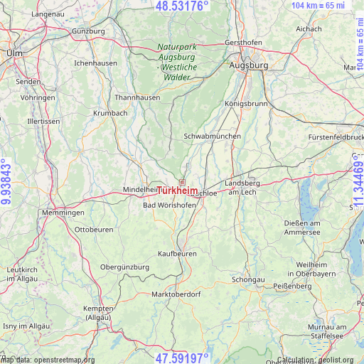
Türkheim GPS coordinates[2]
48° 3' 50.436" North, 10° 38' 29.616" East
| Map corner | latitude | longitude |
|---|---|---|
| Upper-left | 48.53176°, | 9.93843° |
| Center: | 48.06401°, | 10.64156° |
| Lower-right: | 47.59197°, | 11.34469° |
| Map W x H: | 104.5×104.5 km | = 64.9×64.9mi |
| max Lat: | 55.01917° ⇑94.7% North |
| Türkheim: | 48.06401° |
| min Lat: | ⇓5.3% South 47.40724° |
| min Long | Türkheim | max Long |
| 5.92978° | 10.64156° | 14.98853° |
| W 61.5%⇐ | ⇒38.5% E |
Elevation
Elevation of Türkheim is 599 m = 1965 ft, and this is 349.9 m = 1148 ft above average elevation for this country.
| Max E: |
1256 m = 4121 ft | 5% |
| Türkheim | 599 m 1965 ft | |
| Avg. | 249.1 m = 817 ft | |
Min E: |
-5 m = -16 ft | 95% |
See also: Germany elevation on elevation.city.
Geographical zone
Türkheim is located in North temperate zone (between Tropic of Cancer and the Arctic Circle). Distance of this North polar circle is 2057 km =1278.2 mi to North.| Distance of | km | miles | from Türkheim |
|---|---|---|---|
| North Pole | 4662.8 | 2897.3 | to North |
| Arctic Circle | 2057 | 1278.2 | to North |
| Tropic Cancer | 2738.3 | 1701.5 | to South |
| Equator | 5344.2 | 3320.7 | to South |


Nearby cities:
15 places around Türkheim: (largest is in red/bold)
• Amberg
3.1 km =1.9 mi,  84°
84°
• Apfeltrach
11.8 km =7.3 mi,  243°
243°
• Bad Wörishofen
7.2 km =4.5 mi,  207°
207°
• Buchloe
6.9 km =4.3 mi,  115°
115°
• Dirlewang
12.4 km =7.7 mi, 236°
• Ettringen
4.1 km =2.5 mi,  8°
8°
• Hiltenfingen
12.2 km =7.6 mi,  27°
27°
• Jengen
9.5 km =5.9 mi,  138°
138°
• Lamerdingen
7.9 km =4.9 mi,  66°
66°
• Langerringen
12.6 km =7.8 mi,  43°
43°
• Markt Wald
9.2 km =5.7 mi,  331°
331°
• Mindelheim
11.3 km =7 mi,  259°
259°
• Tussenhausen
7.4 km =4.6 mi,  305°
305°
• Waal
12.6 km =7.8 mi,  126°
126°
• Wiedergeltingen
3.6 km =2.2 mi, 138°
Sources, notices
• [Note1] Compared only with cities in Germany existing in our database
• [Src1] Map data: © OpenStreetMap contributors (CC-BY-SA)
• [Src2] Other city data from geonames.org with taken over terms of usage.
• [Src3] Geographical zone / Annual Mean Temperature by Robert A. Rohde @ Wikipedia
