Dattenberg geodata
Dattenberg (Rheinland-Pfalz) is a seat of a fourth-order administrative division; located in Germany in Europe/Berlin (GMT+2) time zone. With population of 1,579 people, there are 5723 cities with bigger population in this country. Compared to other cities in Germany, 51.6% of cities are located further ↑North; 90% of cities are located further →East and 55.9% of cities have higher elevation than Dattenberg. Note1


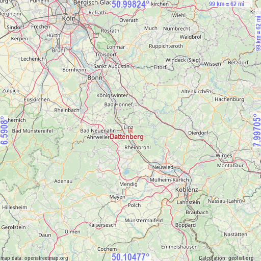
Dattenberg GPS coordinates[2]
50° 33' 13.032" North, 7° 17' 38.148" East
| Map corner | latitude | longitude |
|---|---|---|
| Upper-left | 50.99824°, | 6.5908° |
| Center: | 50.55362°, | 7.29393° |
| Lower-right: | 50.10477°, | 7.99705° |
| Map W x H: | 99.3×99.3 km | = 61.7×61.7mi |
| max Lat: | 55.01917° ⇑51.6% North |
| Dattenberg: | 50.55362° |
| min Lat: | ⇓48.4% South 47.40724° |
| min Long | Dattenberg | max Long |
| 5.92978° | 7.29393° | 14.98853° |
| W 10%⇐ | ⇒90% E |
Elevation
Elevation of Dattenberg is 182 m = 597 ft, and this is 67.1 m = 220 ft below average elevation for this country.
| Max E: |
1256 m = 4121 ft | 55.9% |
| Avg. | 249.1 m = 817 ft | |
| Dattenberg | 182 m = 597 ft | |
Min E: |
-5 m = -16 ft | 44.1% |
See also: Germany elevation on elevation.city.
Geographical zone
Dattenberg is located in North temperate zone (between Tropic of Cancer and the Arctic Circle). Distance of this North polar circle is 1780.1 km =1106.1 mi to North.| Distance of | km | miles | from Dattenberg |
|---|---|---|---|
| North Pole | 4386 | 2725.3 | to North |
| Arctic Circle | 1780.1 | 1106.1 | to North |
| Tropic Cancer | 3015.1 | 1873.5 | to South |
| Equator | 5621 | 3492.7 | to South |


Nearby cities:
15 places around Dattenberg: (largest is in red/bold)
• Bad Breisig
5.4 km =3.4 mi,  183°
183°
• Bad Hönningen
4.3 km =2.7 mi,  162°
162°
• Bruchhausen
6 km =3.7 mi,  328°
328°
• Erpel
5.4 km =3.4 mi,  307°
307°
• Gönnersdorf
8 km =5 mi,  193°
193°
• Kalenborn
7 km =4.3 mi,  12°
12°
• Kasbach-Ohlenberg
3.8 km =2.4 mi, 329°
• Leubsdorf
0.6 km =0.4 mi,  133°
133°
• Linz am Rhein
1.8 km =1.1 mi,  338°
338°
• Ockenfels
2.8 km =1.7 mi, 332°
• Remagen
5.5 km =3.4 mi,  300°
300°
• Rheinbrohl
6.6 km =4.1 mi,  154°
154°
• Sankt Katharinen
7.1 km =4.4 mi,  62°
62°
• Sinzig
3.5 km =2.2 mi,  252°
252°
• Unkel
7.1 km =4.4 mi, 311°
Sources, notices
• [Note1] Compared only with cities in Germany existing in our database
• [Src1] Map data: © OpenStreetMap contributors (CC-BY-SA)
• [Src2] Other city data from geonames.org with taken over terms of usage.
• [Src3] Geographical zone / Annual Mean Temperature by Robert A. Rohde @ Wikipedia
