Hjallerup geodata
Hjallerup (North Denmark) is a populated place; located in Denmark in Europe/Copenhagen (GMT+2) time zone. With population of 3,320 people, there are 192 cities with bigger population in this country. Compared to other cities in Denmark, 95.9% of cities are located further ↓South; 53.5% of cities are located further →East and 52% of cities have higher elevation than Hjallerup. Note1


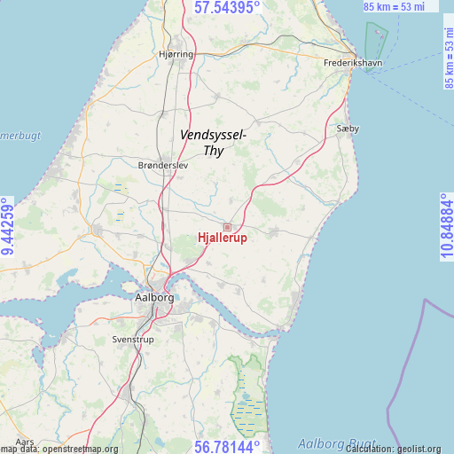
Hjallerup GPS coordinates[2]
57° 9' 52.776" North, 10° 8' 44.556" East
| Map corner | latitude | longitude |
|---|---|---|
| Upper-left | 57.54395°, | 9.44259° |
| Center: | 57.16466°, | 10.14571° |
| Lower-right: | 56.78144°, | 10.84884° |
| Map W x H: | 84.8×84.8 km | = 52.7×52.7mi |
| max Lat: | 57.72093° ⇑4.1% North |
| Hjallerup: | 57.16466° |
| min Lat: | ⇓95.9% South 54.57644° |
| min Long | Hjallerup | max Long |
| 8.12605° | 10.14571° | 15.18662° |
| W 46.5%⇐ | ⇒53.5% E |
Elevation
Elevation of Hjallerup is 19 m = 62 ft, and this is 8.3 m = 27 ft below average elevation for this country.
| Max E: |
114 m = 374 ft | 52% |
| Avg. | 27.3 m = 90 ft | |
| Hjallerup | 19 m = 62 ft | |
Min E: |
0 m = 0 ft | 48% |
See also: Denmark elevation on elevation.city.
Geographical zone
Hjallerup is located in North temperate zone (between Tropic of Cancer and the Arctic Circle). Distance of this North polar circle is 1045.1 km =649.4 mi to North.| Distance of | km | miles | from Hjallerup |
|---|---|---|---|
| North Pole | 3650.9 | 2268.6 | to North |
| Arctic Circle | 1045.1 | 649.4 | to North |
| Tropic Cancer | 3750.2 | 2330.3 | to South |
| Equator | 6356.1 | 3949.5 | to South |


Nearby cities:
15 places around Hjallerup: (largest is in red/bold)
• Aalborg
18.9 km =11.7 mi,  226°
226°
• Brønderslev
17 km =10.6 mi,  313°
313°
• Dronninglund
8.9 km =5.5 mi,  93°
93°
• Gistrup
21.1 km =13.1 mi,  206°
206°
• Hals
21.2 km =13.2 mi,  152°
152°
• Klarup
17.8 km =11.1 mi,  197°
197°
• Nørresundby
17.9 km =11.1 mi, 228°
• Storvorde
18.1 km =11.2 mi,  188°
188°
• Tårs
24.4 km =15.2 mi,  355°
355°
• Vadum
18.2 km =11.3 mi,  253°
253°
• Vestbjerg
11.8 km =7.3 mi, 251°
• Vester Hassing
10.9 km =6.8 mi, 186°
• Vodskov
9.7 km =6 mi, 230°
• Vrå
24.3 km =15.1 mi,  329°
329°
• Åbybro
25.1 km =15.6 mi,  269°
269°
Sources, notices
• [Note1] Compared only with cities in Denmark existing in our database
• [Src1] Map data: © OpenStreetMap contributors (CC-BY-SA)
• [Src2] Other city data from geonames.org with taken over terms of usage.
• [Src3] Geographical zone / Annual Mean Temperature by Robert A. Rohde @ Wikipedia
