Vrå geodata
Vrå (North Denmark) is a populated place; located in Denmark in Europe/Copenhagen (GMT+2) time zone. With population of 2,273 people, there are 275 cities with bigger population in this country. Compared to other cities in Denmark, 97.7% of cities are located further ↓South; 63.5% of cities are located further →East and 55.8% of cities have lower elevation than Vrå. Note1


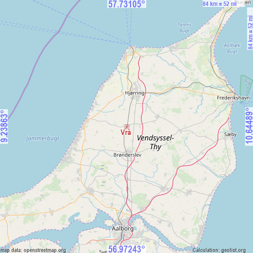
Vrå GPS coordinates[2]
57° 21' 13.32" North, 9° 56' 30.336" East
| Map corner | latitude | longitude |
|---|---|---|
| Upper-left | 57.73105°, | 9.23863° |
| Center: | 57.3537°, | 9.94176° |
| Lower-right: | 56.97243°, | 10.64489° |
| Map W x H: | 84.4×84.3 km | = 52.4×52.4mi |
| max Lat: | 57.72093° ⇑2.3% North |
| Vrå: | 57.3537° |
| min Lat: | ⇓97.7% South 54.57644° |
| min Long | Vrå | max Long |
| 8.12605° | 9.94176° | 15.18662° |
| W 36.5%⇐ | ⇒63.5% E |
Elevation
Elevation of Vrå is 26 m = 85 ft, and this is 1.3 m = 4 ft below average elevation for this country.
| Max E: |
114 m = 374 ft | 44.2% |
| Avg. | 27.3 m = 90 ft | |
| Vrå | 26 m = 85 ft | |
Min E: |
0 m = 0 ft | 55.8% |
See also: Denmark elevation on elevation.city.
Geographical zone
Vrå is located in North temperate zone (between Tropic of Cancer and the Arctic Circle). Distance of this North polar circle is 1024 km =636.3 mi to North.| Distance of | km | miles | from Vrå |
|---|---|---|---|
| North Pole | 3629.9 | 2255.5 | to North |
| Arctic Circle | 1024 | 636.3 | to North |
| Tropic Cancer | 3771.2 | 2343.3 | to South |
| Equator | 6377.1 | 3962.5 | to South |


Nearby cities:
15 places around Vrå: (largest is in red/bold)
• Brønderslev
9.3 km =5.8 mi,  180°
180°
• Dronninglund
30.1 km =18.7 mi,  135°
135°
• Hirtshals
26.1 km =16.2 mi,  2°
2°
• Hjallerup
24.3 km =15.1 mi,  149°
149°
• Hjørring
12.5 km =7.8 mi,  11°
11°
• Kås
23.8 km =14.8 mi,  223°
223°
• Løkken
13.7 km =8.5 mi,  277°
277°
• Nørresundby
32.8 km =20.4 mi, 181°
• Pandrup
21.7 km =13.5 mi,  227°
227°
• Sindal
20.4 km =12.7 mi,  50°
50°
• Tårs
11 km =6.8 mi,  72°
72°
• Vadum
26.7 km =16.6 mi,  191°
191°
• Vestbjerg
24.7 km =15.3 mi, 177°
• Vodskov
27.7 km =17.2 mi,  169°
169°
• Åbybro
24.8 km =15.4 mi,  210°
210°
Sources, notices
• [Note1] Compared only with cities in Denmark existing in our database
• [Src1] Map data: © OpenStreetMap contributors (CC-BY-SA)
• [Src2] Other city data from geonames.org with taken over terms of usage.
• [Src3] Geographical zone / Annual Mean Temperature by Robert A. Rohde @ Wikipedia
