Pandrup geodata
Pandrup (North Denmark) is a populated place; located in Denmark in Europe/Copenhagen (GMT+2) time zone. With population of 2,942 people, there are 216 cities with bigger population in this country. Compared to other cities in Denmark, 96.5% of cities are located further ↓South; 73.7% of cities are located further →East and 77.2% of cities have higher elevation than Pandrup. Note1


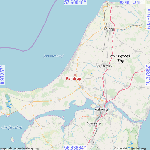
Pandrup GPS coordinates[2]
57° 13' 17.292" North, 9° 40' 32.484" East
| Map corner | latitude | longitude |
|---|---|---|
| Upper-left | 57.60018°, | 8.97257° |
| Center: | 57.22147°, | 9.67569° |
| Lower-right: | 56.83884°, | 10.37882° |
| Map W x H: | 84.7×84.7 km | = 52.6×52.6mi |
| max Lat: | 57.72093° ⇑3.5% North |
| Pandrup: | 57.22147° |
| min Lat: | ⇓96.5% South 54.57644° |
| min Long | Pandrup | max Long |
| 8.12605° | 9.67569° | 15.18662° |
| W 26.3%⇐ | ⇒73.7% E |
Elevation
Elevation of Pandrup is 10 m = 33 ft, and this is 17.3 m = 57 ft below average elevation for this country.
| Max E: |
114 m = 374 ft | 77.2% |
| Avg. | 27.3 m = 90 ft | |
| Pandrup | 10 m = 33 ft | |
Min E: |
0 m = 0 ft | 22.8% |
See also: Denmark elevation on elevation.city.
Geographical zone
Pandrup is located in North temperate zone (between Tropic of Cancer and the Arctic Circle). Distance of this North polar circle is 1038.7 km =645.4 mi to North.| Distance of | km | miles | from Pandrup |
|---|---|---|---|
| North Pole | 3644.6 | 2264.6 | to North |
| Arctic Circle | 1038.7 | 645.4 | to North |
| Tropic Cancer | 3756.5 | 2334.2 | to South |
| Equator | 6362.4 | 3953.4 | to South |


Nearby cities:
15 places around Pandrup: (largest is in red/bold)
• Aalborg
24.2 km =15 mi,  142°
142°
• Brovst
16.6 km =10.3 mi,  213°
213°
• Brønderslev
16.9 km =10.5 mi,  71°
71°
• Fjerritslev
28.8 km =17.9 mi,  239°
239°
• Frejlev
25.4 km =15.8 mi,  160°
160°
• Hjallerup
29 km =18 mi,  102°
102°
• Kås
2.6 km =1.6 mi,  185°
185°
• Løkken
16.7 km =10.4 mi,  8°
8°
• Nibe
26.8 km =16.7 mi,  184°
184°
• Nørresundby
23.4 km =14.5 mi, 140°
• Vadum
15.9 km =9.9 mi, 136°
• Vestbjerg
19.8 km =12.3 mi,  120°
120°
• Vodskov
24.4 km =15.2 mi, 121°
• Vrå
21.7 km =13.5 mi,  47°
47°
• Åbybro
7.3 km =4.5 mi,  153°
153°
Sources, notices
• [Note1] Compared only with cities in Denmark existing in our database
• [Src1] Map data: © OpenStreetMap contributors (CC-BY-SA)
• [Src2] Other city data from geonames.org with taken over terms of usage.
• [Src3] Geographical zone / Annual Mean Temperature by Robert A. Rohde @ Wikipedia
