Calibishie geodata
Calibishie (Saint Andrew) is a populated place; located in Dominica in America/Dominica (GMT-4) time zone. With population of 1,020 people, there are 13 cities with bigger population in this country. Compared to other cities in Dominica, 100% of cities are located further ↓South; 58.8% of cities are located further ←West and 100% of cities have higher elevation than Calibishie. Note1


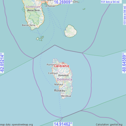
Calibishie GPS coordinates[2]
15° 35' 34.692" North, 61° 20' 56.436" West
| Map corner | latitude | longitude |
|---|---|---|
| Upper-left | 16.26909°, | -62.05214° |
| Center: | 15.59297°, | -61.34901° |
| Lower-right: | 14.91462°, | -60.64589° |
| Map W x H: | 150.6×150.6 km | = 93.6×93.6mi |
| max Lat: | 15.59297° ⇑0% North |
| Calibishie: | 15.59297° |
| min Lat: | ⇓100% South 15.23333° |
| min Long | Calibishie | max Long |
| -61.46667° | -61.34901° | -61.24753° |
| W 58.8%⇐ | ⇒41.2% E |
Elevation
Elevation of Calibishie is 1 m = 3 ft, and this is 79.1 m = 260 ft below average elevation for this country.
| Max E: |
595 m = 1952 ft | 100% |
| Avg. | 80.1 m = 263 ft | |
| Calibishie | 1 m = 3 ft | |
Min E: |
1 m = 3 ft | 0% |
See also: Dominica elevation on elevation.city.
Geographical zone
Calibishie is located in North Torrid zone (between Equator and Tropic of Cancer). Distance of this Northern Tropic circle is 872.1 km =541.9 mi to North.| Distance of | km | miles | from Calibishie |
|---|---|---|---|
| North Pole | 8273.3 | 5140.8 | to North |
| Arctic Circle | 5667.4 | 3521.6 | to North |
| Tropic Cancer | 872.1 | 541.9 | to North |
| Equator | 1733.8 | 1077.3 | to South |


Nearby cities:
15 places around Calibishie: (largest is in red/bold)
• Castle Bruce
19.3 km =12 mi,  149°
149°
• Castle Comfort
34.4 km =21.4 mi,  183°
183°
• Colihaut
17.1 km =10.6 mi,  225°
225°
• La Plaine
31.4 km =19.5 mi,  159°
159°
• Mahaut
26 km =16.2 mi,  191°
191°
• Marigot
9.2 km =5.7 mi,  130°
130°
• Pointe Michel
37.2 km =23.1 mi, 184°
• Pont Cassé
25.2 km =15.7 mi, 180°
• Portsmouth
12.6 km =7.8 mi,  265°
265°
• Rosalie
26.7 km =16.6 mi, 160°
• Roseau
32.7 km =20.3 mi, 187°
• Saint Joseph
23.3 km =14.5 mi,  202°
202°
• Salisbury
19.7 km =12.2 mi,  208°
208°
• Wesley
4.5 km =2.8 mi, 130°
• Woodford Hill
2.3 km =1.4 mi, 125°
Sources, notices
• [Note1] Compared only with cities in Dominica existing in our database
• [Src1] Map data: © OpenStreetMap contributors (CC-BY-SA)
• [Src2] Other city data from geonames.org with taken over terms of usage.
• [Src3] Geographical zone / Annual Mean Temperature by Robert A. Rohde @ Wikipedia
