Los Llanos geodata
Los Llanos (San Pedro de Macorís) is a populated place; located in Dominican Republic in America/Santo_Domingo (GMT-4) time zone. With population of 5,529 people, there are 108 cities with bigger population in this country. Compared to other cities in Dominican Republic, 63.5% of cities are located further ↑North; 91% of cities are located further ←West and 63% of cities have higher elevation than Los Llanos. Note1
Administrative division(s):
- Level 1: San Pedro de Macorís
- Level 2: Los Llanos
- Level 3: Los Llanos
- Level 4: San José De Los Llanos (Zona Urbana)


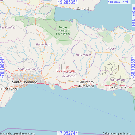
Los Llanos GPS coordinates[2]
18° 37' 13.26" North, 69° 29' 44.916" West
| Map corner | latitude | longitude |
|---|---|---|
| Upper-left | 19.28535°, | -70.19894° |
| Center: | 18.62035°, | -69.49581° |
| Lower-right: | 17.95274°, | -68.79269° |
| Map W x H: | 148.2×148.2 km | = 92.1×92.1mi |
| max Lat: | 19.89131° ⇑63.5% North |
| Los Llanos: | 18.62035° |
| min Lat: | ⇓36.5% South 17.80136° |
| min Long | Los Llanos | max Long |
| -71.85022° | -69.49581° | -68.40431° |
| W 91%⇐ | ⇒9% E |
Elevation
Elevation of Los Llanos is 45 m = 148 ft, and this is 121.3 m = 398 ft below average elevation for this country.
| Max E: |
1242 m = 4075 ft | 63% |
| Avg. | 166.3 m = 546 ft | |
| Los Llanos | 45 m = 148 ft | |
Min E: |
5 m = 16 ft | 37% |
See also: Dominican Republic elevation on elevation.city.
Geographical zone
Los Llanos is located in North Torrid zone (between Equator and Tropic of Cancer). Distance of this Northern Tropic circle is 535.5 km =332.7 mi to North.| Distance of | km | miles | from Los Llanos |
|---|---|---|---|
| North Pole | 7936.7 | 4931.6 | to North |
| Arctic Circle | 5330.8 | 3312.4 | to North |
| Tropic Cancer | 535.5 | 332.7 | to North |
| Equator | 2070.4 | 1286.5 | to South |


Nearby cities:
15 places around Los Llanos: (largest is in red/bold)
• Bayaguana
20.6 km =12.8 mi,  314°
314°
• Boca Chica
21.9 km =13.6 mi,  210°
210°
• El Puerto
18.4 km =11.4 mi,  9°
9°
• El Valle
41.4 km =25.7 mi,  17°
17°
• Ensanche Luperón
44.7 km =27.8 mi,  252°
252°
• Guayabo Dulce
22.6 km =14 mi,  81°
81°
• Guerra
22.7 km =14.1 mi, 252°
• Hato Mayor del Rey
29.7 km =18.5 mi,  57°
57°
• Monte Plata
36.8 km =22.9 mi,  304°
304°
• Quisqueya
11.7 km =7.3 mi,  128°
128°
• Ramón Santana
34.4 km =21.4 mi,  104°
104°
• San Pedro de Macorís
27.1 km =16.8 mi, 133°
• Santo Domingo
44.9 km =27.9 mi, 248°
• Santo Domingo Este
40.8 km =25.4 mi, 248°
• Villa Francisca
44.2 km =27.5 mi, 249°
Sources, notices
• [Note1] Compared only with cities in Dominican Republic existing in our database
• [Src1] Map data: © OpenStreetMap contributors (CC-BY-SA)
• [Src2] Other city data from geonames.org with taken over terms of usage.
• [Src3] Geographical zone / Annual Mean Temperature by Robert A. Rohde @ Wikipedia
