Monte Plata geodata
Monte Plata is a seat of a first-order administrative division; located in Dominican Republic in America/Santo_Domingo (GMT-4) time zone. With population of 15,532 people, there are 47 cities with bigger population in this country. Compared to other cities in Dominican Republic, 53.6% of cities are located further ↑North; 87.7% of cities are located further ←West and 55.9% of cities have higher elevation than Monte Plata. Note1
Administrative division(s):
- Level 1: Monte Plata
- Level 2: Monte Plata
- Level 3: Monte Plata
- Level 4: Monte Plata (Zona Urbana)


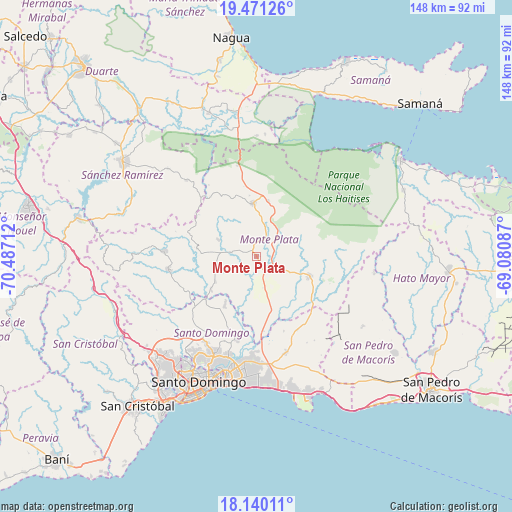
Monte Plata GPS coordinates[2]
18° 48' 25.2" North, 69° 47' 2.364" West
| Map corner | latitude | longitude |
|---|---|---|
| Upper-left | 19.47126°, | -70.48712° |
| Center: | 18.807°, | -69.78399° |
| Lower-right: | 18.14011°, | -69.08087° |
| Map W x H: | 148×148 km | = 92×92mi |
| max Lat: | 19.89131° ⇑53.6% North |
| Monte Plata: | 18.807° |
| min Lat: | ⇓46.4% South 17.80136° |
| min Long | Monte Plata | max Long |
| -71.85022° | -69.78399° | -68.40431° |
| W 87.7%⇐ | ⇒12.3% E |
Elevation
Elevation of Monte Plata is 55 m = 180 ft, and this is 111.3 m = 365 ft below average elevation for this country.
| Max E: |
1242 m = 4075 ft | 55.9% |
| Avg. | 166.3 m = 546 ft | |
| Monte Plata | 55 m = 180 ft | |
Min E: |
5 m = 16 ft | 44.1% |
See also: Dominican Republic elevation on elevation.city.
Geographical zone
Monte Plata is located in North Torrid zone (between Equator and Tropic of Cancer). Distance of this Northern Tropic circle is 514.8 km =319.9 mi to North.| Distance of | km | miles | from Monte Plata |
|---|---|---|---|
| North Pole | 7915.9 | 4918.7 | to North |
| Arctic Circle | 5310 | 3299.5 | to North |
| Tropic Cancer | 514.8 | 319.9 | to North |
| Equator | 2091.1 | 1299.3 | to South |


Nearby cities:
15 places around Monte Plata: (largest is in red/bold)
• Bayaguana
16.9 km =10.5 mi,  111°
111°
• Cevicos
30 km =18.6 mi,  316°
316°
• Don Juan
17.2 km =10.7 mi,  277°
277°
• El Puerto
33.5 km =20.8 mi,  94°
94°
• Ensanche Luperón
36.3 km =22.6 mi,  199°
199°
• Esperalvillo
26.5 km =16.5 mi,  271°
271°
• Gonzalo
16.4 km =10.2 mi,  12°
12°
• Guerra
28.9 km =18 mi,  162°
162°
• La Agustina
37.6 km =23.4 mi, 204°
• Los Botados
23.8 km =14.8 mi,  249°
249°
• Los Llanos
36.8 km =22.9 mi,  124°
124°
• Majagual
26.6 km =16.5 mi,  348°
348°
• Sabana Grande de Boyá
15.4 km =9.6 mi,  356°
356°
• Santo Domingo Este
36.2 km =22.5 mi,  192°
192°
• Yamasá
25.7 km =16 mi,  261°
261°
Sources, notices
• [Note1] Compared only with cities in Dominican Republic existing in our database
• [Src1] Map data: © OpenStreetMap contributors (CC-BY-SA)
• [Src2] Other city data from geonames.org with taken over terms of usage.
• [Src3] Geographical zone / Annual Mean Temperature by Robert A. Rohde @ Wikipedia
