Azua geodata
Azua is a seat of a first-order administrative division; located in Dominican Republic in America/Santo_Domingo (GMT-4) time zone. With population of 59,139 people, there are 19 cities with bigger population in this country. Compared to other cities in Dominican Republic, 80.1% of cities are located further ↑North; 55% of cities are located further →East and 55.9% of cities have lower elevation than Azua. Note1
Administrative division(s):
- Level 1: Azua
- Level 2: Azua
- Level 3: Azua
- Level 4: Azua De Compostela (Zona Urbana)


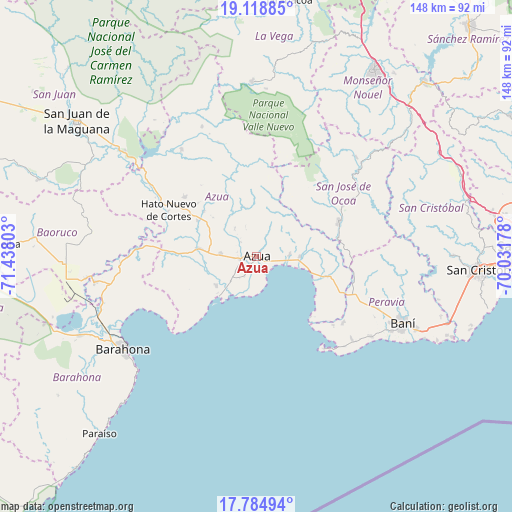
Azua GPS coordinates[2]
18° 27' 11.484" North, 70° 44' 5.64" West
| Map corner | latitude | longitude |
|---|---|---|
| Upper-left | 19.11885°, | -71.43803° |
| Center: | 18.45319°, | -70.7349° |
| Lower-right: | 17.78494°, | -70.03178° |
| Map W x H: | 148.3×148.3 km | = 92.1×92.1mi |
| max Lat: | 19.89131° ⇑80.1% North |
| Azua: | 18.45319° |
| min Lat: | ⇓19.9% South 17.80136° |
| min Long | Azua | max Long |
| -71.85022° | -70.7349° | -68.40431° |
| W 45%⇐ | ⇒55% E |
Elevation
Elevation of Azua is 86 m = 282 ft, and this is 80.3 m = 263 ft below average elevation for this country.
| Max E: |
1242 m = 4075 ft | 44.1% |
| Avg. | 166.3 m = 546 ft | |
| Azua | 86 m = 282 ft | |
Min E: |
5 m = 16 ft | 55.9% |
See also: Azua elevation on elevation.city.
Geographical zone
Azua is located in North Torrid zone (between Equator and Tropic of Cancer). Distance of this Northern Tropic circle is 554.1 km =344.3 mi to North.| Distance of | km | miles | from Azua |
|---|---|---|---|
| North Pole | 7955.3 | 4943.2 | to North |
| Arctic Circle | 5349.4 | 3324 | to North |
| Tropic Cancer | 554.1 | 344.3 | to North |
| Equator | 2051.8 | 1274.9 | to South |


Nearby cities:
15 places around Azua: (largest is in red/bold)
• Bohechío
44.7 km =27.8 mi,  323°
323°
• El Guayabal
34.7 km =21.6 mi,  341°
341°
• Estebanía
9.7 km =6 mi,  87°
87°
• Las Charcas
12.4 km =7.7 mi, 91°
• Matanzas
40.8 km =25.4 mi,  124°
124°
• Padre Las Casas
37.7 km =23.4 mi,  325°
325°
• Palmar de Ocoa
23.4 km =14.5 mi,  138°
138°
• Peralta
14.8 km =9.2 mi,  345°
345°
• Pueblo Viejo
6.8 km =4.2 mi,  210°
210°
• Sabana Buey
29.9 km =18.6 mi,  131°
131°
• Sabana Yegua
41.7 km =25.9 mi,  314°
314°
• San José de Ocoa
26.2 km =16.3 mi,  66°
66°
• Tábara Arriba
20.1 km =12.5 mi, 310°
• Villarpando
39.4 km =24.5 mi, 305°
• Yayas de Viajama
26.6 km =16.5 mi, 310°
Sources, notices
• [Note1] Compared only with cities in Dominican Republic existing in our database
• [Src1] Map data: © OpenStreetMap contributors (CC-BY-SA)
• [Src2] Other city data from geonames.org with taken over terms of usage.
• [Src3] Geographical zone / Annual Mean Temperature by Robert A. Rohde @ Wikipedia
