Tadmaït geodata
Tadmaït (Boumerdes) is a populated place; located in Algeria in Africa/Algiers (GMT+1) time zone. With population of 20,952 people, there are 223 cities with bigger population in this country. Compared to other cities in Algeria, 90.7% of cities are located further ↓South; 55.8% of cities are located further ←West and 86.8% of cities have higher elevation than Tadmaït. Note1


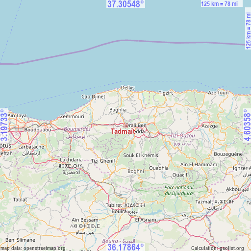
Tadmaït GPS coordinates[2]
36° 44' 38.868" North, 3° 54' 1.62" East
| Map corner | latitude | longitude |
|---|---|---|
| Upper-left | 37.30548°, | 3.19733° |
| Center: | 36.74413°, | 3.90045° |
| Lower-right: | 36.17864°, | 4.60358° |
| Map W x H: | 125.3×125.3 km | = 77.9×77.9mi |
| max Lat: | 36.92917° ⇑9.3% North |
| Tadmaït: | 36.74413° |
| min Lat: | ⇓90.7% South 22.785° |
| min Long | Tadmaït | max Long |
| -8.14743° | 3.90045° | 8.46667° |
| W 55.8%⇐ | ⇒44.2% E |
Elevation
Elevation of Tadmaït is 52 m = 171 ft, and this is 386.5 m = 1268 ft below average elevation for this country.
| Max E: |
1392 m = 4567 ft | 86.8% |
| Avg. | 438.5 m = 1439 ft | |
| Tadmaït | 52 m = 171 ft | |
Min E: |
5 m = 16 ft | 13.2% |
See also: Algeria elevation on elevation.city.
Geographical zone
Tadmaït is located in North temperate zone (between Tropic of Cancer and the Arctic Circle). Distance of this Northern Tropic circle is 1479.6 km =919.4 mi to South.| Distance of | km | miles | from Tadmaït |
|---|---|---|---|
| North Pole | 5921.5 | 3679.4 | to North |
| Arctic Circle | 3315.6 | 2060.2 | to North |
| Tropic Cancer | 1479.6 | 919.4 | to South |
| Equator | 4085.6 | 2538.7 | to South |


Nearby cities:
15 places around Tadmaït: (largest is in red/bold)
• Beni Amrane
28.9 km =18 mi,  252°
252°
• Beni Douala
21.4 km =13.3 mi,  130°
130°
• Boghni
22.9 km =14.2 mi,  168°
168°
• Boudjima
23.3 km =14.5 mi,  73°
73°
• Chabet el Ameur
21.9 km =13.6 mi,  237°
237°
• Dellys
19.3 km =12 mi,  3°
3°
• Draa Ben Khedda
5.6 km =3.5 mi,  101°
101°
• Draa el Mizan
23.9 km =14.9 mi,  194°
194°
• Makouda
15.2 km =9.4 mi, 72°
• Naciria
6.1 km =3.8 mi,  272°
272°
• Tirmitine
12.4 km =7.7 mi,  144°
144°
• Tizi Gheniff
20.6 km =12.8 mi,  212°
212°
• Tizi Ouzou
13.5 km =8.4 mi,  105°
105°
• Tizi Rached
27.2 km =16.9 mi, 107°
• Tizi-n-Tleta
26.1 km =16.2 mi,  147°
147°
Sources, notices
• [Note1] Compared only with cities in Algeria existing in our database
• [Src1] Map data: © OpenStreetMap contributors (CC-BY-SA)
• [Src2] Other city data from geonames.org with taken over terms of usage.
• [Src3] Geographical zone / Annual Mean Temperature by Robert A. Rohde @ Wikipedia
