Chabet el Ameur geodata
Chabet el Ameur (Boumerdes) is a populated place; located in Algeria in Africa/Algiers (GMT+1) time zone. With population of 19,522 people, there are 233 cities with bigger population in this country. Compared to other cities in Algeria, 79.1% of cities are located further ↓South; 53.1% of cities are located further ←West and 55% of cities have higher elevation than Chabet el Ameur. Note1


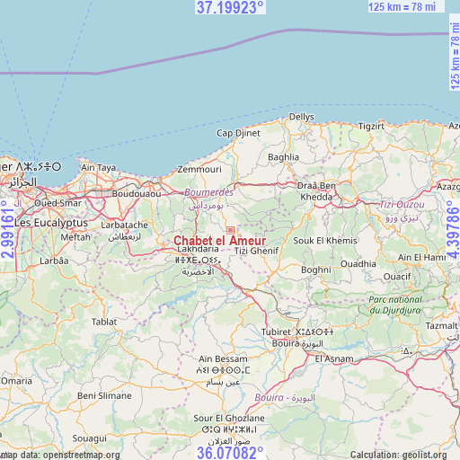
Chabet el Ameur GPS coordinates[2]
36° 38' 13.524" North, 3° 41' 41.064" East
| Map corner | latitude | longitude |
|---|---|---|
| Upper-left | 37.19923°, | 2.99161° |
| Center: | 36.63709°, | 3.69474° |
| Lower-right: | 36.07082°, | 4.39786° |
| Map W x H: | 125.5×125.5 km | = 78×78mi |
| max Lat: | 36.92917° ⇑20.9% North |
| Chabet el Ameur: | 36.63709° |
| min Lat: | ⇓79.1% South 22.785° |
| min Long | Chabet el Ameur | max Long |
| -8.14743° | 3.69474° | 8.46667° |
| W 53.1%⇐ | ⇒46.9% E |
Elevation
Elevation of Chabet el Ameur is 245 m = 804 ft, and this is 193.5 m = 635 ft below average elevation for this country.
| Max E: |
1392 m = 4567 ft | 55% |
| Avg. | 438.5 m = 1439 ft | |
| Chabet el Ameur | 245 m = 804 ft | |
Min E: |
5 m = 16 ft | 45% |
See also: Algeria elevation on elevation.city.
Geographical zone
Chabet el Ameur is located in North temperate zone (between Tropic of Cancer and the Arctic Circle). Distance of this Northern Tropic circle is 1467.7 km =912 mi to South.| Distance of | km | miles | from Chabet el Ameur |
|---|---|---|---|
| North Pole | 5933.4 | 3686.8 | to North |
| Arctic Circle | 3327.5 | 2067.6 | to North |
| Tropic Cancer | 1467.7 | 912 | to South |
| Equator | 4073.7 | 2531.3 | to South |


Nearby cities:
15 places around Chabet el Ameur: (largest is in red/bold)
• Arbatache
28.9 km =18 mi,  270°
270°
• Beni Amrane
9.8 km =6.1 mi,  290°
290°
• Boghni
25.4 km =15.8 mi,  114°
114°
• Boudouaou
27.3 km =17 mi, 291°
• Boumerdas
24.1 km =15 mi,  306°
306°
• Draa Ben Khedda
26.2 km =16.3 mi,  65°
65°
• Draa el Mizan
16.7 km =10.4 mi,  132°
132°
• Lakhdaria
12.1 km =7.5 mi,  228°
228°
• Naciria
17.2 km =10.7 mi,  45°
45°
• Ouled Moussa
29.7 km =18.5 mi,  280°
280°
• Tadmaït
21.9 km =13.6 mi,  57°
57°
• Thenia
15.8 km =9.8 mi, 308°
• Tirmitine
25.6 km =15.9 mi,  85°
85°
• Tizi Gheniff
8.9 km =5.5 mi, 127°
• Tizi Ouzou
32.4 km =20.1 mi,  75°
75°
Sources, notices
• [Note1] Compared only with cities in Algeria existing in our database
• [Src1] Map data: © OpenStreetMap contributors (CC-BY-SA)
• [Src2] Other city data from geonames.org with taken over terms of usage.
• [Src3] Geographical zone / Annual Mean Temperature by Robert A. Rohde @ Wikipedia
