Dellys geodata
Dellys (Boumerdes) is a populated place; located in Algeria in Africa/Algiers (GMT+1) time zone. With population of 26,384 people, there are 194 cities with bigger population in this country. Compared to other cities in Algeria, 99.6% of cities are located further ↓South; 56.6% of cities are located further ←West and 84.1% of cities have higher elevation than Dellys. Note1


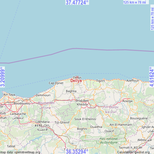
Dellys GPS coordinates[2]
36° 55' 1.776" North, 3° 54' 47.196" East
| Map corner | latitude | longitude |
|---|---|---|
| Upper-left | 37.47724°, | 3.20999° |
| Center: | 36.91716°, | 3.91311° |
| Lower-right: | 36.35294°, | 4.61624° |
| Map W x H: | 125×125 km | = 77.7×77.7mi |
| max Lat: | 36.92917° ⇑0.4% North |
| Dellys: | 36.91716° |
| min Lat: | ⇓99.6% South 22.785° |
| min Long | Dellys | max Long |
| -8.14743° | 3.91311° | 8.46667° |
| W 56.6%⇐ | ⇒43.4% E |
Elevation
Elevation of Dellys is 63 m = 207 ft, and this is 375.5 m = 1232 ft below average elevation for this country.
| Max E: |
1392 m = 4567 ft | 84.1% |
| Avg. | 438.5 m = 1439 ft | |
| Dellys | 63 m = 207 ft | |
Min E: |
5 m = 16 ft | 15.9% |
See also: Algeria elevation on elevation.city.
Geographical zone
Dellys is located in North temperate zone (between Tropic of Cancer and the Arctic Circle). Distance of this Northern Tropic circle is 1498.9 km =931.4 mi to South.| Distance of | km | miles | from Dellys |
|---|---|---|---|
| North Pole | 5902.3 | 3667.5 | to North |
| Arctic Circle | 3296.4 | 2048.3 | to North |
| Tropic Cancer | 1498.9 | 931.4 | to South |
| Equator | 4104.8 | 2550.6 | to South |


Nearby cities:
15 places around Dellys: (largest is in red/bold)
• Arhribs
38 km =23.6 mi,  111°
111°
• Beni Amrane
39.9 km =24.8 mi,  225°
225°
• Beni Douala
36.4 km =22.6 mi,  155°
155°
• Boudjima
24.8 km =15.4 mi,  121°
121°
• Chabet el Ameur
36.7 km =22.8 mi,  211°
211°
• Draa Ben Khedda
20.8 km =12.9 mi,  167°
167°
• Makouda
19.8 km =12.3 mi,  137°
137°
• Naciria
20.3 km =12.6 mi,  200°
200°
• Tadmaït
19.3 km =12 mi,  183°
183°
• Thenia
38.2 km =23.7 mi,  236°
236°
• Timizart
34 km =21.1 mi, 112°
• Tirmitine
29.9 km =18.6 mi, 168°
• Tizi Gheniff
38.6 km =24 mi, 198°
• Tizi Ouzou
25.7 km =16 mi,  152°
152°
• Tizi Rached
36.9 km =22.9 mi, 137°
Sources, notices
• [Note1] Compared only with cities in Algeria existing in our database
• [Src1] Map data: © OpenStreetMap contributors (CC-BY-SA)
• [Src2] Other city data from geonames.org with taken over terms of usage.
• [Src3] Geographical zone / Annual Mean Temperature by Robert A. Rohde @ Wikipedia
