Boghni geodata
Boghni (Tizi Ouzou) is a populated place; located in Algeria in Africa/Algiers (GMT+1) time zone. With population of 54,666 people, there are 88 cities with bigger population in this country. Compared to other cities in Algeria, 71.7% of cities are located further ↓South; 57% of cities are located further ←West and 54.7% of cities have higher elevation than Boghni. Note1


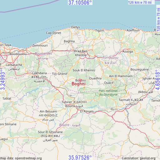
Boghni GPS coordinates[2]
36° 32' 31.992" North, 3° 57' 11.016" East
| Map corner | latitude | longitude |
|---|---|---|
| Upper-left | 37.10506°, | 3.24993° |
| Center: | 36.54222°, | 3.95306° |
| Lower-right: | 35.97526°, | 4.65618° |
| Map W x H: | 125.6×125.6 km | = 78×78mi |
| max Lat: | 36.92917° ⇑28.3% North |
| Boghni: | 36.54222° |
| min Lat: | ⇓71.7% South 22.785° |
| min Long | Boghni | max Long |
| -8.14743° | 3.95306° | 8.46667° |
| W 57%⇐ | ⇒43% E |
Elevation
Elevation of Boghni is 249 m = 817 ft, and this is 189.5 m = 622 ft below average elevation for this country.
| Max E: |
1392 m = 4567 ft | 54.7% |
| Avg. | 438.5 m = 1439 ft | |
| Boghni | 249 m = 817 ft | |
Min E: |
5 m = 16 ft | 45.3% |
See also: Boghni elevation on elevation.city.
Geographical zone
Boghni is located in North temperate zone (between Tropic of Cancer and the Arctic Circle). Distance of this Northern Tropic circle is 1457.2 km =905.5 mi to South.| Distance of | km | miles | from Boghni |
|---|---|---|---|
| North Pole | 5943.9 | 3693.4 | to North |
| Arctic Circle | 3338.1 | 2074.2 | to North |
| Tropic Cancer | 1457.2 | 905.5 | to South |
| Equator | 4063.1 | 2524.7 | to South |


Nearby cities:
15 places around Boghni: (largest is in red/bold)
• Beni Douala
14.4 km =8.9 mi,  53°
53°
• Bouïra
19.2 km =11.9 mi,  193°
193°
• Chabet el Ameur
25.4 km =15.8 mi,  294°
294°
• Draa Ben Khedda
21.4 km =13.3 mi,  2°
2°
• Draa el Mizan
10.7 km =6.6 mi,  266°
266°
• L’Arbaa Naït Irathen
24.1 km =15 mi,  65°
65°
• Makouda
28.8 km =17.9 mi,  19°
19°
• Naciria
25.1 km =15.6 mi,  334°
334°
• Tadmaït
22.9 km =14.2 mi,  348°
348°
• Tirmitine
12.7 km =7.9 mi,  11°
11°
• Tizi Gheniff
16.8 km =10.4 mi, 287°
• Tizi Ouzou
20.6 km =12.8 mi, 23°
• Tizi Rached
25.7 km =16 mi,  55°
55°
• Tizi-n-Tleta
9.3 km =5.8 mi,  87°
87°
• ’Aïn el Hammam
31.6 km =19.6 mi, 85°
Sources, notices
• [Note1] Compared only with cities in Algeria existing in our database
• [Src1] Map data: © OpenStreetMap contributors (CC-BY-SA)
• [Src2] Other city data from geonames.org with taken over terms of usage.
• [Src3] Geographical zone / Annual Mean Temperature by Robert A. Rohde @ Wikipedia
