Tõrva geodata
Tõrva (Valgamaa) is a seat of a second-order administrative division; located in Estonia in Europe/Tallinn (GMT+3) time zone. With population of 3,112 people, there are 35 cities with bigger population in this country. Compared to other cities in Estonia, 93.2% of cities are located further ↑North; 58.9% of cities are located further ←West and 64.7% of cities have lower elevation than Tõrva. Note1


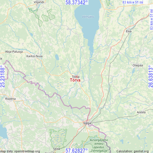
Tõrva GPS coordinates[2]
58° 0' 10.008" North, 25° 56' 6" East
| Map corner | latitude | longitude |
|---|---|---|
| Upper-left | 58.37342°, | 25.23188° |
| Center: | 58.00278°, | 25.935° |
| Lower-right: | 57.62827°, | 26.63813° |
| Map W x H: | 82.9×82.9 km | = 51.5×51.5mi |
| max Lat: | 59.57639° ⇑93.2% North |
| Tõrva: | 58.00278° |
| min Lat: | ⇓6.8% South 57.72778° |
| min Long | Tõrva | max Long |
| 22.24646° | 25.935° | 28.19028° |
| W 58.9%⇐ | ⇒41.1% E |
Elevation
Elevation of Tõrva is 63 m = 207 ft, and this is 9.8 m = 32 ft above average elevation for this country.
| Max E: |
141 m = 463 ft | 35.3% |
| Tõrva | 63 m 207 ft | |
| Avg. | 53.2 m = 175 ft | |
Min E: |
6 m = 20 ft | 64.7% |
See also: Estonia elevation on elevation.city.
Geographical zone
Tõrva is located in North temperate zone (between Tropic of Cancer and the Arctic Circle). Distance of this North polar circle is 951.9 km =591.5 mi to North.| Distance of | km | miles | from Tõrva |
|---|---|---|---|
| North Pole | 3557.8 | 2210.7 | to North |
| Arctic Circle | 951.9 | 591.5 | to North |
| Tropic Cancer | 3843.4 | 2388.2 | to South |
| Equator | 6449.3 | 4007.4 | to South |


Nearby cities:
15 places around Tõrva: (largest is in red/bold)
• Abja-Paluoja
37 km =23 mi,  291°
291°
• Antsla
40.8 km =25.4 mi,  118°
118°
• Elva
37.6 km =23.4 mi,  49°
49°
• Karksi
24.1 km =15 mi,  301°
301°
• Karksi-Nuia
24.6 km =15.3 mi, 297°
• Käärdi
36.1 km =22.4 mi, 50°
• Puhja
43.8 km =27.2 mi,  30°
30°
• Puka
17.9 km =11.1 mi,  73°
73°
• Ramsi
41.1 km =25.5 mi,  325°
325°
• Rõngu
24.3 km =15.1 mi, 49°
• Tsirguliina
22.2 km =13.8 mi,  135°
135°
• Valga
25.9 km =16.1 mi,  165°
165°
• Vana-Antsla
38.4 km =23.9 mi,  113°
113°
• Viiratsi
43.4 km =27 mi,  336°
336°
• Viljandi
45 km =28 mi, 333°
Sources, notices
• [Note1] Compared only with cities in Estonia existing in our database
• [Src1] Map data: © OpenStreetMap contributors (CC-BY-SA)
• [Src2] Other city data from geonames.org with taken over terms of usage.
• [Src3] Geographical zone / Annual Mean Temperature by Robert A. Rohde @ Wikipedia
