Vana-Antsla geodata
Vana-Antsla (Võrumaa) is a populated place; located in Estonia in Europe/Tallinn (GMT+3) time zone. With population of 1,468 people, there are 62 cities with bigger population in this country. Compared to other cities in Estonia, 95.8% of cities are located further ↑North; 73.2% of cities are located further ←West and 88.9% of cities have lower elevation than Vana-Antsla. Note1


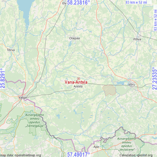
Vana-Antsla GPS coordinates[2]
57° 51' 57.996" North, 26° 31' 55.992" East
| Map corner | latitude | longitude |
|---|---|---|
| Upper-left | 58.23816°, | 25.8291° |
| Center: | 57.86611°, | 26.53222° |
| Lower-right: | 57.49017°, | 27.23535° |
| Map W x H: | 83.2×83.2 km | = 51.7×51.7mi |
| max Lat: | 59.57639° ⇑95.8% North |
| Vana-Antsla: | 57.86611° |
| min Lat: | ⇓4.2% South 57.72778° |
| min Long | Vana-Antsla | max Long |
| 22.24646° | 26.53222° | 28.19028° |
| W 73.2%⇐ | ⇒26.8% E |
Elevation
Elevation of Vana-Antsla is 86 m = 282 ft, and this is 32.8 m = 108 ft above average elevation for this country.
| Max E: |
141 m = 463 ft | 11.1% |
| Vana-Antsla | 86 m 282 ft | |
| Avg. | 53.2 m = 175 ft | |
Min E: |
6 m = 20 ft | 88.9% |
See also: Estonia elevation on elevation.city.
Geographical zone
Vana-Antsla is located in North temperate zone (between Tropic of Cancer and the Arctic Circle). Distance of this North polar circle is 967.1 km =600.9 mi to North.| Distance of | km | miles | from Vana-Antsla |
|---|---|---|---|
| North Pole | 3573 | 2220.2 | to North |
| Arctic Circle | 967.1 | 600.9 | to North |
| Tropic Cancer | 3828.2 | 2378.7 | to South |
| Equator | 6434.1 | 3998 | to South |


Nearby cities:
15 places around Vana-Antsla: (largest is in red/bold)
• Antsla
4.5 km =2.8 mi,  173°
173°
• Kanepi
18.6 km =11.6 mi,  45°
45°
• Kose
30.5 km =19 mi,  101°
101°
• Käärdi
38.7 km =24 mi,  349°
349°
• Mammaste
37.6 km =23.4 mi, 53°
• Parksepa
27.1 km =16.8 mi,  79°
79°
• Puka
27.2 km =16.9 mi,  318°
318°
• Põlva
38.3 km =23.8 mi,  55°
55°
• Rõngu
35.3 km =21.9 mi,  331°
331°
• Rõuge
27.1 km =16.8 mi,  124°
124°
• Tsirguliina
19.8 km =12.3 mi,  268°
268°
• Tõrva
38.4 km =23.9 mi,  293°
293°
• Valga
30.3 km =18.8 mi,  251°
251°
• Väimela
28.9 km =18 mi, 84°
• Võru
29 km =18 mi, 97°
Sources, notices
• [Note1] Compared only with cities in Estonia existing in our database
• [Src1] Map data: © OpenStreetMap contributors (CC-BY-SA)
• [Src2] Other city data from geonames.org with taken over terms of usage.
• [Src3] Geographical zone / Annual Mean Temperature by Robert A. Rohde @ Wikipedia
