Ramsi geodata
Ramsi (Viljandimaa) is a populated place; located in Estonia in Europe/Tallinn (GMT+3) time zone. With population of 732 people, there are 121 cities with bigger population in this country. Compared to other cities in Estonia, 78.4% of cities are located further ↑North; 51.1% of cities are located further ←West and 69.5% of cities have lower elevation than Ramsi. Note1


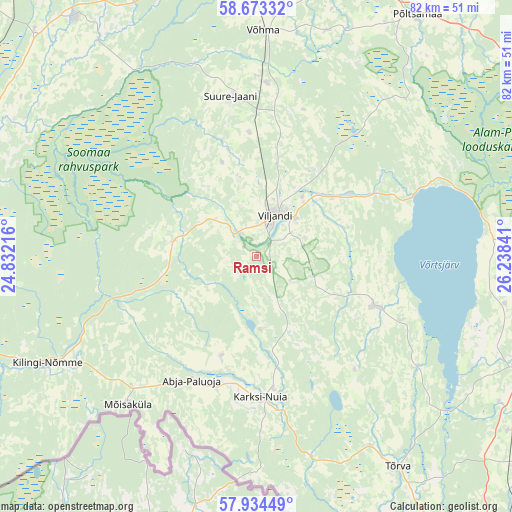
Ramsi GPS coordinates[2]
58° 18' 20.988" North, 25° 32' 7.008" East
| Map corner | latitude | longitude |
|---|---|---|
| Upper-left | 58.67332°, | 24.83216° |
| Center: | 58.30583°, | 25.53528° |
| Lower-right: | 57.93449°, | 26.23841° |
| Map W x H: | 82.2×82.1 km | = 51.1×51mi |
| max Lat: | 59.57639° ⇑78.4% North |
| Ramsi: | 58.30583° |
| min Lat: | ⇓21.6% South 57.72778° |
| min Long | Ramsi | max Long |
| 22.24646° | 25.53528° | 28.19028° |
| W 51.1%⇐ | ⇒48.9% E |
Elevation
Elevation of Ramsi is 66 m = 217 ft, and this is 12.8 m = 42 ft above average elevation for this country.
| Max E: |
141 m = 463 ft | 30.5% |
| Ramsi | 66 m 217 ft | |
| Avg. | 53.2 m = 175 ft | |
Min E: |
6 m = 20 ft | 69.5% |
See also: Estonia elevation on elevation.city.
Geographical zone
Ramsi is located in North temperate zone (between Tropic of Cancer and the Arctic Circle). Distance of this North polar circle is 918.2 km =570.5 mi to North.| Distance of | km | miles | from Ramsi |
|---|---|---|---|
| North Pole | 3524.1 | 2189.8 | to North |
| Arctic Circle | 918.2 | 570.5 | to North |
| Tropic Cancer | 3877.1 | 2409.1 | to South |
| Equator | 6483 | 4028.3 | to South |


Nearby cities:
15 places around Ramsi: (largest is in red/bold)
• Abja-Paluoja
22.8 km =14.2 mi,  208°
208°
• Karksi
21.2 km =13.2 mi,  171°
171°
• Karksi-Nuia
22.6 km =14 mi,  175°
175°
• Kilingi-Nõmme
37.6 km =23.4 mi,  242°
242°
• Mustla
31.8 km =19.8 mi,  233°
233°
• Mõisaküla
31.3 km =19.4 mi,  220°
220°
• Olustvere
27.6 km =17.1 mi,  3°
3°
• Suure-Jaani
25.9 km =16.1 mi,  351°
351°
• Tihemetsa
33.8 km =21 mi, 238°
• Tõrva
41.1 km =25.5 mi,  145°
145°
• Vana-Võidu
11.7 km =7.3 mi,  36°
36°
• Viiratsi
8.5 km =5.3 mi, 44°
• Viljandi
7.2 km =4.5 mi,  26°
26°
• Võhma
35.9 km =22.3 mi, 1°
• Võisiku
42.3 km =26.3 mi, 31°
Sources, notices
• [Note1] Compared only with cities in Estonia existing in our database
• [Src1] Map data: © OpenStreetMap contributors (CC-BY-SA)
• [Src2] Other city data from geonames.org with taken over terms of usage.
• [Src3] Geographical zone / Annual Mean Temperature by Robert A. Rohde @ Wikipedia
