Antsla geodata
Antsla (Võrumaa) is a seat of a second-order administrative division; located in Estonia in Europe/Tallinn (GMT+3) time zone. In our database, there are 184 cities with bigger population. Compared to other cities in Estonia, 97.4% of cities are located further ↑North; 74.7% of cities are located further ←West and 88.4% of cities have lower elevation than Antsla. Note1


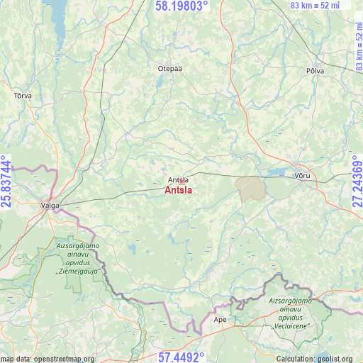
Antsla GPS coordinates[2]
57° 49' 32.016" North, 26° 32' 26.016" East
| Map corner | latitude | longitude |
|---|---|---|
| Upper-left | 58.19803°, | 25.83744° |
| Center: | 57.82556°, | 26.54056° |
| Lower-right: | 57.4492°, | 27.24369° |
| Map W x H: | 83.3×83.3 km | = 51.8×51.8mi |
| max Lat: | 59.57639° ⇑97.4% North |
| Antsla: | 57.82556° |
| min Lat: | ⇓2.6% South 57.72778° |
| min Long | Antsla | max Long |
| 22.24646° | 26.54056° | 28.19028° |
| W 74.7%⇐ | ⇒25.3% E |
Elevation
Elevation of Antsla is 85 m = 279 ft, and this is 31.8 m = 104 ft above average elevation for this country.
| Max E: |
141 m = 463 ft | 11.6% |
| Antsla | 85 m 279 ft | |
| Avg. | 53.2 m = 175 ft | |
Min E: |
6 m = 20 ft | 88.4% |
See also: Estonia elevation on elevation.city.
Geographical zone
Antsla is located in North temperate zone (between Tropic of Cancer and the Arctic Circle). Distance of this North polar circle is 971.6 km =603.7 mi to North.| Distance of | km | miles | from Antsla |
|---|---|---|---|
| North Pole | 3577.5 | 2223 | to North |
| Arctic Circle | 971.6 | 603.7 | to North |
| Tropic Cancer | 3823.7 | 2375.9 | to South |
| Equator | 6429.6 | 3995.2 | to South |


Nearby cities:
15 places around Antsla: (largest is in red/bold)
• Himmaste
42.1 km =26.2 mi,  48°
48°
• Kanepi
21.7 km =13.5 mi,  36°
36°
• Kose
29.4 km =18.3 mi,  92°
92°
• Mammaste
40.1 km =24.9 mi, 48°
• Parksepa
27.8 km =17.3 mi,  70°
70°
• Puka
31.1 km =19.3 mi,  323°
323°
• Põlva
40.7 km =25.3 mi, 50°
• Rõngu
39.5 km =24.5 mi,  334°
334°
• Rõuge
24.4 km =15.2 mi,  116°
116°
• Tsirguliina
20.7 km =12.9 mi,  280°
280°
• Tõrva
40.8 km =25.4 mi,  298°
298°
• Valga
29.7 km =18.5 mi,  259°
259°
• Vana-Antsla
4.5 km =2.8 mi,  353°
353°
• Väimela
29.2 km =18.1 mi,  75°
75°
• Võru
28.4 km =17.6 mi, 88°
Sources, notices
• [Note1] Compared only with cities in Estonia existing in our database
• [Src1] Map data: © OpenStreetMap contributors (CC-BY-SA)
• [Src2] Other city data from geonames.org with taken over terms of usage.
• [Src3] Geographical zone / Annual Mean Temperature by Robert A. Rohde @ Wikipedia
