Kehtna geodata
Kehtna (Raplamaa) is a populated place; located in Estonia in Europe/Tallinn (GMT+3) time zone. With population of 1,579 people, there are 57 cities with bigger population in this country. Compared to other cities in Estonia, 52.1% of cities are located further ↓South; 65.3% of cities are located further →East and 67.9% of cities have lower elevation than Kehtna. Note1


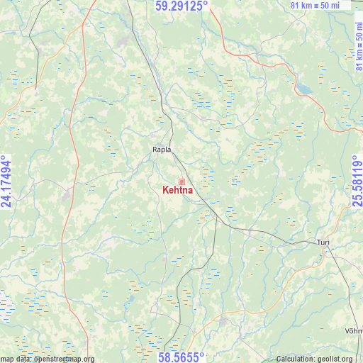
Kehtna GPS coordinates[2]
58° 55' 49.008" North, 24° 52' 41.016" East
| Map corner | latitude | longitude |
|---|---|---|
| Upper-left | 59.29125°, | 24.17494° |
| Center: | 58.93028°, | 24.87806° |
| Lower-right: | 58.5655°, | 25.58119° |
| Map W x H: | 80.7×80.7 km | = 50.1×50.1mi |
| max Lat: | 59.57639° ⇑47.9% North |
| Kehtna: | 58.93028° |
| min Lat: | ⇓52.1% South 57.72778° |
| min Long | Kehtna | max Long |
| 22.24646° | 24.87806° | 28.19028° |
| W 34.7%⇐ | ⇒65.3% E |
Elevation
Elevation of Kehtna is 65 m = 213 ft, and this is 11.8 m = 39 ft above average elevation for this country.
| Max E: |
141 m = 463 ft | 32.1% |
| Kehtna | 65 m 213 ft | |
| Avg. | 53.2 m = 175 ft | |
Min E: |
6 m = 20 ft | 67.9% |
See also: Estonia elevation on elevation.city.
Geographical zone
Kehtna is located in North temperate zone (between Tropic of Cancer and the Arctic Circle). Distance of this North polar circle is 848.7 km =527.4 mi to North.| Distance of | km | miles | from Kehtna |
|---|---|---|---|
| North Pole | 3454.6 | 2146.6 | to North |
| Arctic Circle | 848.7 | 527.4 | to North |
| Tropic Cancer | 3946.5 | 2452.2 | to South |
| Equator | 6552.4 | 4071.5 | to South |


Nearby cities:
15 places around Kehtna: (largest is in red/bold)
• Alu
12.3 km =7.6 mi,  326°
326°
• Ardu
34 km =21.1 mi,  56°
56°
• Juuru
15.5 km =9.6 mi,  15°
15°
• Järvakandi
17.1 km =10.6 mi,  190°
190°
• Kaerepere
4.4 km =2.7 mi, 333°
• Kohila
27.3 km =17 mi,  345°
345°
• Kose
32.4 km =20.1 mi,  31°
31°
• Kose-Uuemõisa
32.7 km =20.3 mi, 23°
• Märjamaa
25.9 km =16.1 mi,  263°
263°
• Orgita
25.8 km =16 mi,  269°
269°
• Rapla
9.9 km =6.2 mi, 330°
• Särevere
35.3 km =21.9 mi,  116°
116°
• Türi
34.6 km =21.5 mi,  112°
112°
• Vyatsa
33 km =20.5 mi,  98°
98°
• Vändra
32.7 km =20.3 mi,  163°
163°
Sources, notices
• [Note1] Compared only with cities in Estonia existing in our database
• [Src1] Map data: © OpenStreetMap contributors (CC-BY-SA)
• [Src2] Other city data from geonames.org with taken over terms of usage.
• [Src3] Geographical zone / Annual Mean Temperature by Robert A. Rohde @ Wikipedia
