Alatskivi geodata
Alatskivi (Tartu) is a seat of a second-order administrative division; located in Estonia in Europe/Tallinn (GMT+3) time zone. With population of 430 people, there are 179 cities with bigger population in this country. Compared to other cities in Estonia, 61.6% of cities are located further ↑North; 91.1% of cities are located further ←West and 57.9% of cities have higher elevation than Alatskivi. Note1


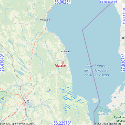
Alatskivi GPS coordinates[2]
58° 35' 53.016" North, 27° 8' 0.996" East
| Map corner | latitude | longitude |
|---|---|---|
| Upper-left | 58.9625°, | 26.43049° |
| Center: | 58.59806°, | 27.13361° |
| Lower-right: | 58.22978°, | 27.83674° |
| Map W x H: | 81.5×81.5 km | = 50.6×50.6mi |
| max Lat: | 59.57639° ⇑61.6% North |
| Alatskivi: | 58.59806° |
| min Lat: | ⇓38.4% South 57.72778° |
| min Long | Alatskivi | max Long |
| 22.24646° | 27.13361° | 28.19028° |
| W 91.1%⇐ | ⇒8.9% E |
Elevation
Elevation of Alatskivi is 48 m = 157 ft, and this is 5.2 m = 17 ft below average elevation for this country.
| Max E: |
141 m = 463 ft | 57.9% |
| Avg. | 53.2 m = 175 ft | |
| Alatskivi | 48 m = 157 ft | |
Min E: |
6 m = 20 ft | 42.1% |
See also: Estonia elevation on elevation.city.
Geographical zone
Alatskivi is located in North temperate zone (between Tropic of Cancer and the Arctic Circle). Distance of this North polar circle is 885.7 km =550.3 mi to North.| Distance of | km | miles | from Alatskivi |
|---|---|---|---|
| North Pole | 3491.6 | 2169.6 | to North |
| Arctic Circle | 885.7 | 550.3 | to North |
| Tropic Cancer | 3909.6 | 2429.3 | to South |
| Equator | 6515.5 | 4048.5 | to South |


Nearby cities:
15 places around Alatskivi: (largest is in red/bold)
• Ahja
44 km =27.3 mi,  184°
184°
• Ilmatsalu
41.4 km =25.7 mi,  235°
235°
• Kallaste
7.4 km =4.6 mi,  12°
12°
• Koosa
9.3 km =5.8 mi,  201°
201°
• Kuremaa
38.5 km =23.9 mi,  293°
293°
• Kurepalu
35.4 km =22 mi,  208°
208°
• Kõrveküla
28.1 km =17.5 mi,  226°
226°
• Lohkva
32.1 km =19.9 mi,  217°
217°
• Luunja
30.7 km =19.1 mi, 208°
• Mustvee
30 km =18.6 mi,  338°
338°
• Palamuse
33.5 km =20.8 mi, 286°
• Tartu
33.9 km =21.1 mi, 224°
• Torma
33 km =20.5 mi,  316°
316°
• Võnnu
35.9 km =22.3 mi,  187°
187°
• Ülenurme
39.3 km =24.4 mi, 217°
Sources, notices
• [Note1] Compared only with cities in Estonia existing in our database
• [Src1] Map data: © OpenStreetMap contributors (CC-BY-SA)
• [Src2] Other city data from geonames.org with taken over terms of usage.
• [Src3] Geographical zone / Annual Mean Temperature by Robert A. Rohde @ Wikipedia
