Ahja geodata
Ahja (Põlvamaa) is a populated place; located in Estonia in Europe/Tallinn (GMT+3) time zone. With population of 616 people, there are 135 cities with bigger population in this country. Compared to other cities in Estonia, 82.6% of cities are located further ↑North; 89.5% of cities are located further ←West and 50.5% of cities have lower elevation than Ahja. Note1


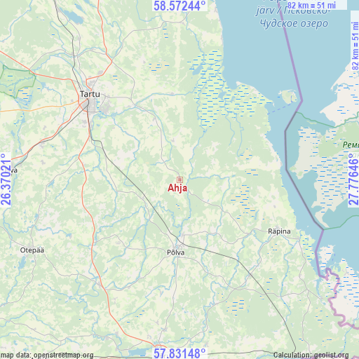
Ahja GPS coordinates[2]
58° 12' 14.004" North, 27° 4' 23.988" East
| Map corner | latitude | longitude |
|---|---|---|
| Upper-left | 58.57244°, | 26.37021° |
| Center: | 58.20389°, | 27.07333° |
| Lower-right: | 57.83148°, | 27.77646° |
| Map W x H: | 82.4×82.4 km | = 51.2×51.2mi |
| max Lat: | 59.57639° ⇑82.6% North |
| Ahja: | 58.20389° |
| min Lat: | ⇓17.4% South 57.72778° |
| min Long | Ahja | max Long |
| 22.24646° | 27.07333° | 28.19028° |
| W 89.5%⇐ | ⇒10.5% E |
Elevation
Elevation of Ahja is 54 m = 177 ft, and this is 0.8 m = 3 ft above average elevation for this country.
| Max E: |
141 m = 463 ft | 49.5% |
| Ahja | 54 m 177 ft | |
| Avg. | 53.2 m = 175 ft | |
Min E: |
6 m = 20 ft | 50.5% |
See also: Estonia elevation on elevation.city.
Geographical zone
Ahja is located in North temperate zone (between Tropic of Cancer and the Arctic Circle). Distance of this North polar circle is 929.5 km =577.6 mi to North.| Distance of | km | miles | from Ahja |
|---|---|---|---|
| North Pole | 3535.4 | 2196.8 | to North |
| Arctic Circle | 929.5 | 577.6 | to North |
| Tropic Cancer | 3865.7 | 2402 | to South |
| Equator | 6471.7 | 4021.3 | to South |


Nearby cities:
15 places around Ahja: (largest is in red/bold)
• Himmaste
14.1 km =8.8 mi,  179°
179°
• Kanepi
30.8 km =19.1 mi,  217°
217°
• Kurepalu
18.6 km =11.6 mi,  313°
313°
• Kõrveküla
29.8 km =18.5 mi,  325°
325°
• Lohkva
24.4 km =15.2 mi,  318°
318°
• Luunja
20.3 km =12.6 mi, 326°
• Mammaste
15.3 km =9.5 mi,  186°
186°
• Põlva
16 km =9.9 mi, 180°
• Räpina
25.7 km =16 mi,  117°
117°
• Suure-Kambja
21.6 km =13.4 mi,  274°
274°
• Tartu
28.3 km =17.6 mi, 313°
• Vastse-Kuuste
9.4 km =5.8 mi,  244°
244°
• Veriora
27.6 km =17.1 mi,  143°
143°
• Võnnu
8.4 km =5.2 mi,  349°
349°
• Ülenurme
23.9 km =14.9 mi,  301°
301°
Sources, notices
• [Note1] Compared only with cities in Estonia existing in our database
• [Src1] Map data: © OpenStreetMap contributors (CC-BY-SA)
• [Src2] Other city data from geonames.org with taken over terms of usage.
• [Src3] Geographical zone / Annual Mean Temperature by Robert A. Rohde @ Wikipedia
